Hello again everybody, it’s me once more. This time we’ll be going into the Northern Alps again, but with a much larger objective as a target: The joint-third tallest mountain in Japan: Mount (oku)-Hotaka (3,190m). There are a number of routes that one can access Mount Hotaka, but with it still being the snow season in Japan, this limits some of the options one can take safely. I’ll explain the route this time with a map below:
The route taken this time! Spanning two days, I started from Kamikochi just past 05:00 after arriving via night bus, and would ascend up the valley passing by Mount Myojin (明神岳) marked as the blue cross #2, then heading up towards Mount Mae-Hotaka (前穂高岳) marked with blue cross #1. Due to time constraints I would not ascend the latter, but instead make a beeline for Mount Hotaka itself, traversing over a slightly dangerous area of ridgewalking highlighted in yellow on the map. After summitting, all that remains on Day 1 would be to descend to red cross #1, where Hotaka mountain lodge was located, and where I would spend an evening. The next day I would set off early at around 06:00 so as to descend on as hard snow as possible, down a rather dangerously steep area called the Zaitengrad (ザイテングラード) – then proceed into the valley once more for a slow winding walk back into civilisation, eventually ending in Kamikochi by lunchtime of day two. For references sake, as I will mention them again later, I imagine, blue cross #3 indicates Mount Karasawa (涸沢岳), and blue cross #4 indicates loosely where Mount Jonen is, the mountain I ascended in the previous blog entry. Additionally, the yellow section highlighted between Nishihotaka/Main Hotaka is known as the Gendarme (ジャンダルム), and is marked as an expert route even in the summer, so an area to be avoided for certain during the snowy seasons!
This trip was decided slightly on a whim (due to there being a good break in the weather from the typical rain/overcast-ness), but either way, it is certainly a course not to be underestimated in any shape or form. I deliberately took two days for this as I did not want to unnecessarily rush myself on the first day, as I was aware of the risks of the area surrounding Mount Hotaka, even if I would be avoiding the highly accident-prone Gendarme. As such, I set off from Kamikochi just past 05:00 for the rather long day ahead, heading towards what would turn out the be the tallest mountain I have ascended so far in my experience of climbing.
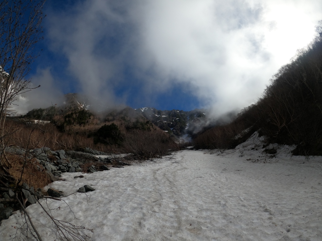
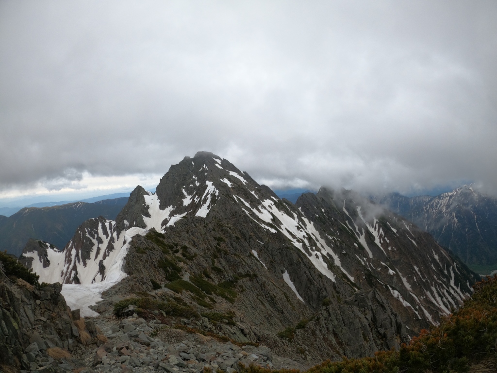
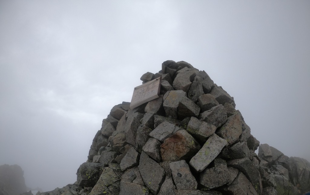
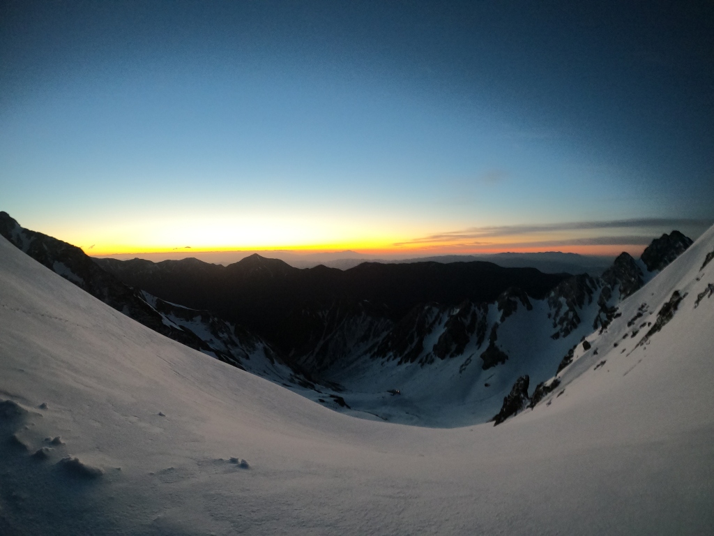
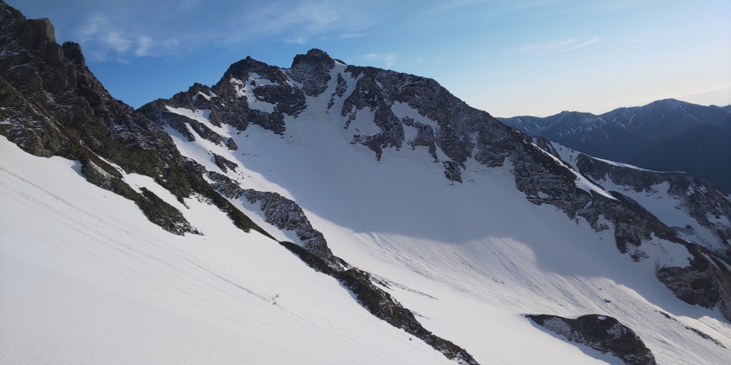
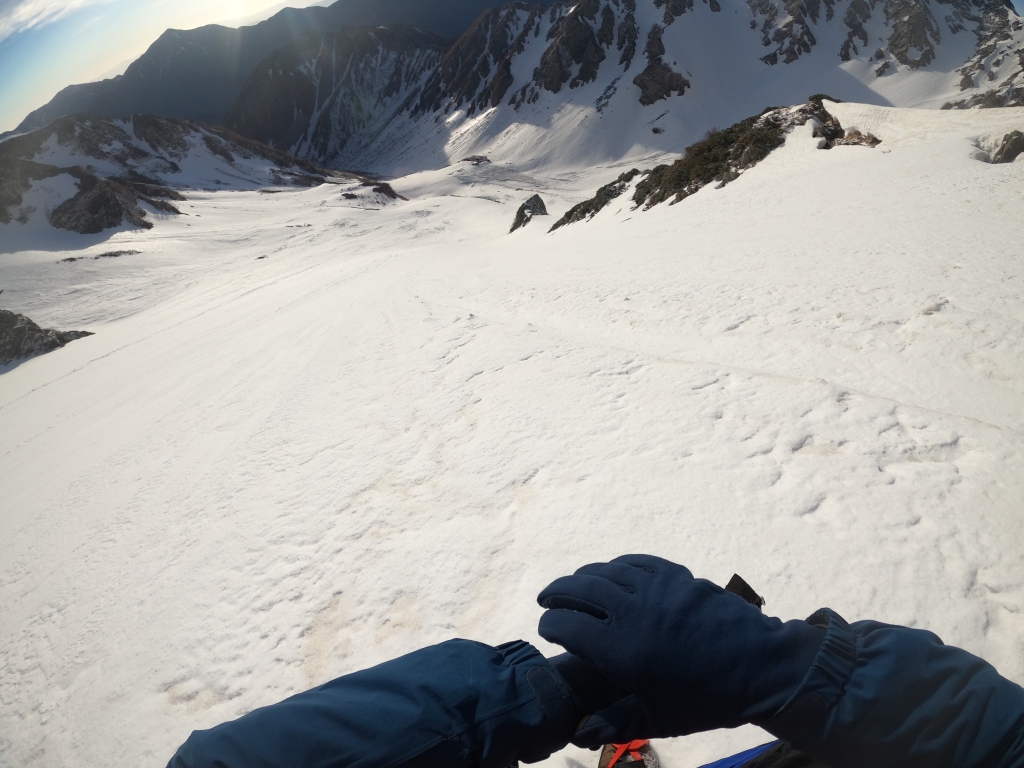
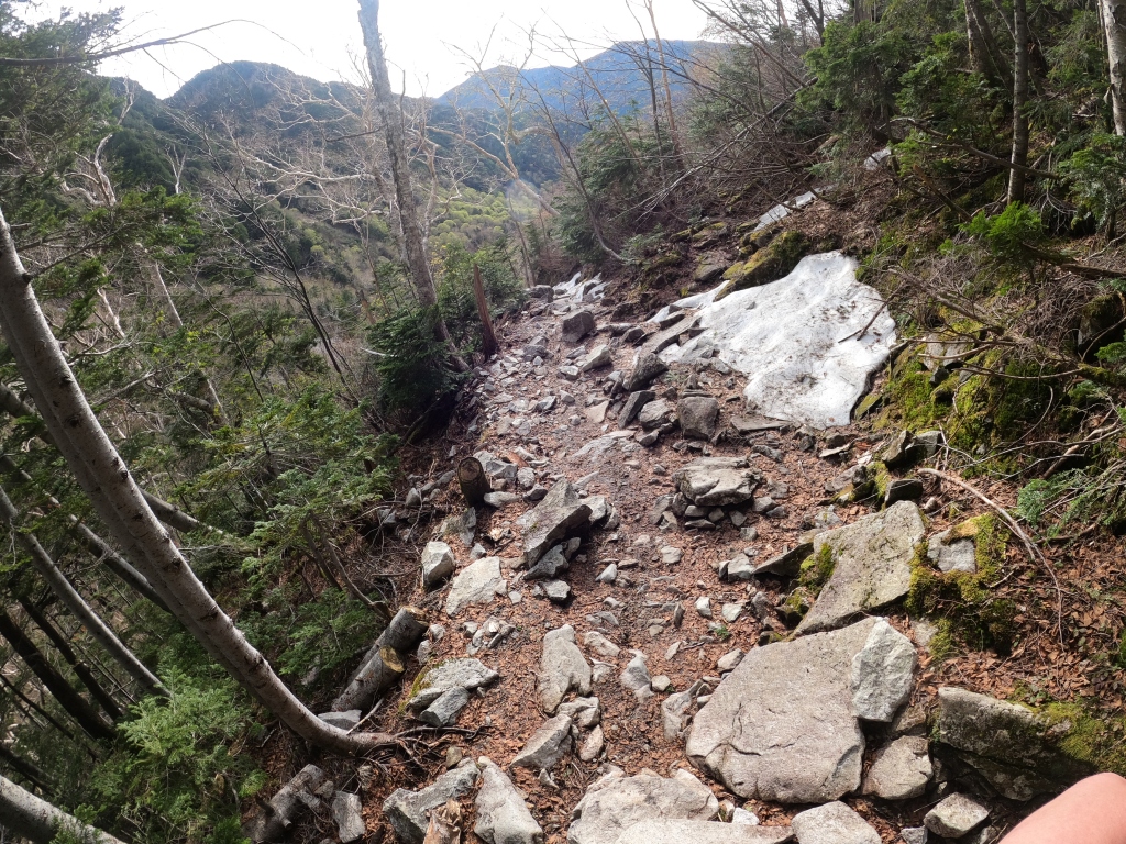
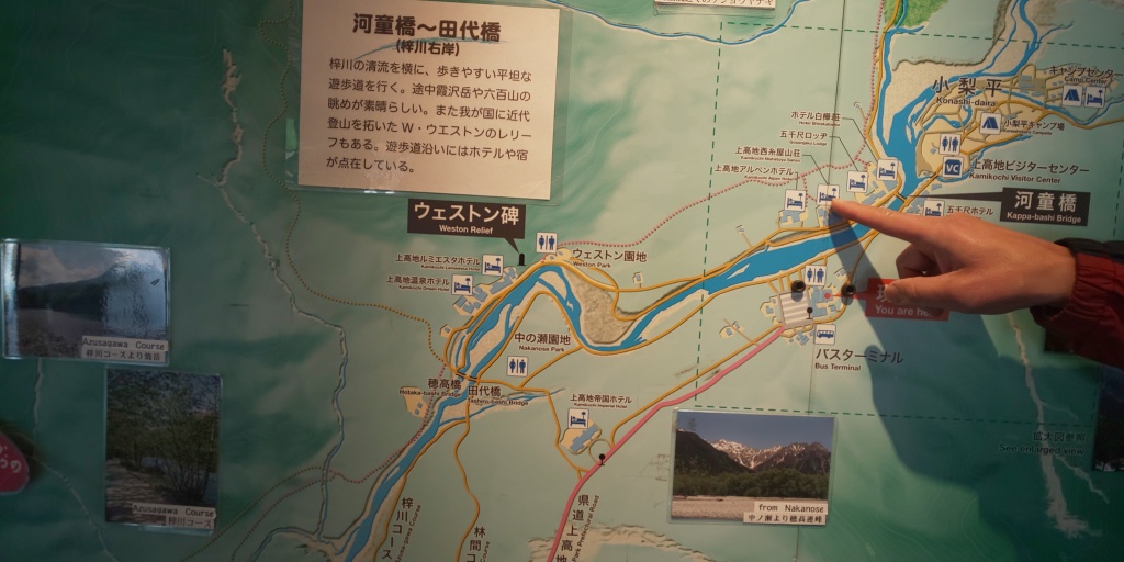
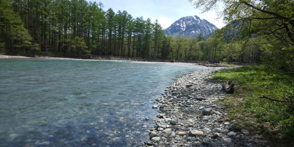
This was taken shortly after the bus stop, facing towards Mount Hotaka, sleeping in the clouds. Slightly concerning considering I would need to head directly into said clouds, and limited visibility on a mountain like Hotaka would not bode particularly well, but we press on regardless!The Kappa Bridge (河童橋), located in central Kamikochi, with the same mountain range pictured from before in the background. You will see in a later picture that this makes for a very picturesque scene when clear, explaining the (expected) congestion of tourists often found in the area.Early signs of the cloud cover (fortunately) being fast-moving, showing breaks in the grim, overcast like weather a short amount of walking had shown thus far. The water quality around the Kamikochi area was also really good, so I took advantage of that and filled up a couple of containers with it before heading towards the mountains after crossing the Kappa Bridge.Certainly a scary sight (perhaps even more so than seeing a bear itself!), but a nice gesture to mountain climbers and casual walkers alike. I also liked how the maintenance team went the extra mile to add an English translation for those who can’t decipher Japanese!I was momentarily spooked by the black shadow in centre-frame here, fearing it may be one of the aforementioned bears, but drew a sigh of relief upon realising it was just a bit of shrubbery. The first part of the path continued as pictured for a good 30 minutes before opening up to a stone valley of sorts.Looking towards the Gendarme area in the distance (the yellow highlighted area on the map, North of Mount Nishihotaka, and Southwest of Mount Oku-Hotaka), hiding behind the increasingly scarce cloud cover. Certainly a good sign of things to come!Ascending up the stone valley towards the “true” ascent of Mae-Hotaka. This was taken some time before arriving at Dakezawa Mountain Hut (岳沢ヒュッテ), the last vestige of humanity for a while, as the next signs of people would not be until after finishing Mount Oku-Ho, and descending down to Hotaka Mountain Lodge.Looking down towards Kamikochi, and simultaneously being surprised by the amount I had ascended thus far. The rocks very quickly transformed into snow, but I stubbornly ascended without crampons until Dakezawa Hut for 10 minutes more after this (The hut is over to the top-left from this picture), as I didn’t want to quite take a break just yet! The weather was, fortunately, continuing the trend of clearing up even more as I ascended, which acted as a nice vote of confidence for the remainder of the day.Passing by Dakezawa Hut (the red point on the map down to the bottom-right here), and looking back once more towards Kamikochi, this time looking considerably further away. Additionally, I will probably reference this a number of times in the blog post, but the mountains in centre shot from right-left are Mount Yake (焼岳), and Mount Norikura (乗鞍岳). Mount Ontake (御嶽山) can also be seen off into the distance beyond Norikura should the weather be clear enough.A metal ladder (the Achilles heel to crampons…) – seemingly a rarity on this course, with rock climbing being much more commonplace. There was also surprisingly little amounts of snow on certain areas of the course leading up to Mae-Hotaka, but not enough to justify safely removing crampons, too. Slightly vexing. Mount Nishihotaka to the left, and the Gendarme in all its jagged glory in the distance. Certainly not a route I’d like to risk taking with snow still around, but something I’m looking forward to challenging in a couple of months.An example of the aforementioned rock climbing areas. It was somewhat of a challenge to shimmy through with my build (and backpack), but managed in the end!An example of one of many snowdrifts on the way up to Mae-Hotaka. 10-12 spike crampons are a necessity, especially in this season, along with an ice axe-like tool of sorts. Surprisingly stamina-sapping too, so this took a bit more time than anticipated.Another shot of the surrounding mountains of Mount Hotaka, as pictured earlier on, but this time from considerably higher elevation (2,700m) – You can also make out Mount Ontake in the distance this time (faintly), with its distinct crown shaped peak jutting out behind Mount Norikura in centre shot.A nice rock-climbing section, which acted as a pleasant break from the somewhat incessant snow ascents thus far. It’s also worth mentioning that I was still on my lonesome up until this point, not having encountered a single soul (human or otherwise), and was only accompanied by the occasional sound of helicopters overhead delivering supplies to the various mountain lodges in the area.Slightly fish-eyed, but an apt representation of the trail heading towards Okuhotaka – on the map the ridge walk seemed fairly simple, but I would be in for a rather unpleasant surprise in the next 5 minutes…I ended up sliding down the snow ridge pictured, picking up speed very quickly down the Southern ridge for a good 40-50 metres before finally managing to skewer my ice axe into the snow to stop my descent. Fortunately no major injuries sustained, but a mental shock to say the least, as if I did not have my crampons/ice axe I would have ran the risk of repeating Mount Tsurugi from last year… Either way, I would need to ascend the 50 metres that I lost, adding on a bit more time than was expected to begin with. Heyho, at least I’m still alive! I steeled myself to take more care on the snow traverses for the rest of the ridge, whilst pressing on.Mount Hotaka’s peak majestically standing in the distance, under increasingly ominous looking clouds. Please don’t rain!The sweeping landscape off to the South once more. Mount Mae-Hotaka, skipped for brevity’s sake on this journey, but certainly a peak I would like to return to one day. For reference, Mount Myojin (明神岳) is also lurking in the clouds to the right, and is scalable from the Kamikochi basin.Looking this time towards the North, beyond the naturally built snow wall whilst traversing the ridge line towards Mount Hotaka. In centre-shot off in the distance is Mount Jonen – the peak I ascended on my last visit to the Northern Alps. It was nice to be able to see what it looked like from a different perspective, rather than from the East (Kofu city’s direction, and the location of the Ichi/Ninozawa trailheads)An unfortunate turn of events, as the cloud cover decided to roll in, at what I can only say to be the worst timing possible. This would add on even more time to the ascent, as I could not afford to rush within cloud cover, lest I lose my footing (once more…) on a snow ridge or even worse, the rocks.The penultimate snow ridge traverse, featuring heavy cloud cover. Spooky, to say the least.Wandering through the clouds, and slowly but surely approaching the summit of Mount Hotaka.The summit marker of Mount Hotaka, reached at around 16:00 – a good 11 hours after beginning from Kamikochi. Initially I had planned to be here for around 14:00 or so, but made the (in retrospect) correct decision to take extra care/time on the ascent towards Mae-Hotaka, as I did not want to rush things unnecessarily, especially considering I had another day tomorrow.The summit marker and myself, the latter of which looking fairly chipper considering the long hike up until this point! The temperature was chilly considering the amount of wind at the summit, so I did not dilly-dally for too long, and pressed on down the mountain before long.The beginning of the descent towards Hotaka Mountain Lodge, with (frustratingly) signs of the cloud cover easing up just as I left the summit…!A stellar view of the mountains off to the West from Mount Hotaka, with Mount Kasa (笠ヶ岳) being the most likely mountain in centre-shot, another of the Hundred Famous Mountains of the Northern Alps.Looking North just prior to reaching the Mountain Lodge, with Mount Karasawa (涸沢岳) in the foreground, and the Northern peak of the Hotaka series, Kitahotaka-dake (北穂高岳) off to the right. Mount Yari (槍ヶ岳) would also normally be seen from this vantage point, but is obscured by the cloud cover between Karasawa and Kitaho, unfortunately. Dinner after arriving at the Mountain Lodge. I was impressed that they served salmon, and the free refills of both rice and miso soup was very much appreciated. I went to bed fairly early (20:00) in preparation for the next day, which would be considerably less taxing than this first, long day.The moon (and possibly Mount Kasa?) off in the West at the break of dawn.The beginnings of a sunrise, taken just outside the Hotaka Mountain Lodge, looking down the Zaitengarde area blanketed with snow. Mount Jonen’s peak can also be seen left of centre-shot, jutting out fairly conspicuously, and Mae-Hotaka is also peaking out from right of shot. The time was around 04:30 or so when taking this.Looking towards Mount Hotaka, be warned, however, that the peak on the right is not Hotaka’s summit, but a small peak just prior to it! Just outside the door of the Mountain Lodge, with a big wall of snow just outside.06:00, just after leaving the Mountain Lodge. This was incredibly steep, and the picture doesn’t really do it justice, but you’ll be able to see what I mean a bit further down!Looking South, towards the ridge line I had traversed yesterday. Mount Mae-Hotaka is on the left, and Oku-Hotaka is somewhere behind the snow wall on the right-hand side.North, and Hitahotaka. A short rest whilst descending. Despite it being so early, the jacket and gloves would be coming off shortly due to the heat from the sun refracting off the snow!Karasawa Hut (涸沢ヒュッテ), and signs of an avalanche’s debris just to the right hand side. At first glance it appears that the avalanche stopped just short of the tent site in front of the Hut.As promised earlier, a shot looking towards the area I had descended from. Centre shot is Oku-Hotaka, and the small-looking dip to the right hand side is where the Hotaka Mountain Lodge is located. Amazingly, in the span of only an hour, I had descended a total of 500-600 metres or so… Slipping there would have been unfortunate, and if only I could ski, I imagine the descent would be a lot of fun.The end of the snow slowly becoming clearer, and descending further down into the valley that eventually loops into Kamikochi.300 metres of descent later, back to forested paths, however, unlike the route up via Dakezawa Hut, this one was littered with many more fallen trees and rocks that had tumbled down from higher up. For safety’s sake I quickly strapped on my helmet once more (just in case).Arriving back at an estuary that feeds back into the main river further south, with water levels surprisingly low despite the season.Although at first glance sturdily built, this bridge was incredibly wobbly! I also took off my crampons from this point on, as no more snow was to make an appearance for the rest of the journey back to civilisation. It’s also generally considered “manners” to refrain from using crampons on bridges such as these, due to being made from wood, and crampons are very good at damaging such a material.Looking back down the route whence I had come. There was very little change in elevation for the rest of the 13km journey back into Kamikochi, making it a cakewalk if compared to the monster descent from earlier on.An isolated peak that stands just before the Karasawa col, distinctly lacking snow, despite being a good 2,500m or so.Looking down the river, and the direction to be headed toward.Replenishing energy stocks with some soft scoop icecream. This was at Tokuzawa mountain lodge, which had a rather large camping site available for public use. I imagine there’s also a fee of some sorts attached, too.Looking back towards the direction I had travelled from, the snowy mountains now seeming like a different world entirely.Pretty much back at civilisation by this point. Mount Myojin can be seen in the distance, this shot taken from the South.A family of monkeys whilst travelling along the easy going forest path. They seemed to take an interest in my camera, but (fortunately) left me be otherwise.Back at the Kappa Bridge, this time with a “proper” view of the Gendarme, Mount Hotaka, and Mount Myojin off in the distance. There was also an uncomfortable amount of people around the area, perhaps explained by it being nearly midday by this point.Due to my bus being considerably later (15:40), I visited the tourist centre and took some directions to a place for lunch that wasn’t “tourist priced”.The lunch in question. Pork cutlet, salad, a LOT of rice, and some miso soup. 1,200 yen in all (12 dollars/9 pounds or so).After relaxing in an onsen post-lunch, I took a little stroll by the river once more, and took this shot of Mount Yake in the distance. Funnily enough, that will also be the next mountain I tackle, but would be a good few weeks until now (but in about a week at the time of writing).
That concludes my two-day trip to Mount Hotaka, with a return via Karasawa. The journey up on the first day took considerably longer than I anticipated, however, this was not too much of an issue due to the amount of time I had allocated to the first day. I had expected it to be fairly difficult, so I’m glad I managed to have a nice, relaxing second day with lunch and a hot spring upon returning to Kamikochi.
Just some technical points concerning the route. The area between Mao-Ho and Oku-Ho was deceptively challenging, and is something that I think people considering this route should keep in mind. Additionally, the descent immediately after Oku-ho on the way to the mountain lodge was likewise challenging in places (I slipped down a few metres on the snow at one pont), so please keep that in mind. Finally, I stressed this in the captions, but the descent via the Zaitengrarde (spelling?) (ザイテングラード) was albeit enjoyable, incredibly dangerous should one not be equipped with the correct gear. As it was the snow season when I went, I took 10 spike crampons and an ice axe with me, but 12 spike crampons may very well have been a better choice. Light/chain snow spikes would likely not cut it, even in June I imagine, so make sure to check the snow conditions with the local mountain lodges (Hotaka/Karasawa) if you’re considering going at that time!
Either way, a very enjoyable couple of days, and I’m looking forward to revisiting Mount Hotaka (hopefully with better weather) come the summer via the Gendarme. For now that’s all I have to write this time, so thank you very much for reading along, and I will see you in the next blog post, which will likely be Mount Yake (also of the Northern Alps).
Office worker based in Tokyo, Japan. Native English speaker, Native fluency in Japanese (Can translate to a degree). Very large interest in mountains and other nature-abundant areas, and also my blog's namesake.
View more posts
One thought on “Mount Hotaka: Hyakumeizan #31 – Two day trip in the Northern Alps featuring snow (again) (25.05.2021): 奥穂高岳「日本第三最高峰」”
Thanks so much for all the details and photos. You seem pretty comfortable taking risks that I would never take 🙂 Hoping to climb Hotaka in July or August this year!


Thanks so much for all the details and photos. You seem pretty comfortable taking risks that I would never take 🙂 Hoping to climb Hotaka in July or August this year!
LikeLike