Hello again everybody, (as always), long time no see. This is the first of three parts that will make up the Kyushu mountain series that I almost finished back in early January. This first part will cover three mountains in central Kyushu that are almost equidistant from one another: Mount Aso (1,592m), Mount Kuju (1,791m), and Mount Sobo (1,756m). The former two are relatively well known for being active and dormant volcanoes respectively, whilst Mount Sobo has long since ceased volcanic activity since at least the mid-Meiji period in Japan. Perhaps due to this, Mount Sobo was also not anywhere near as popular as Aso or Kuju, with the latter even attracting couples to come hiking the mountain with their dogs in tow.
Mount Aso is also well-known for having one of, if not the largest caldera formed by a previous eruption hundreds of years ago, with the circumference measuring approximately 120 kilometres in distance. Aso is also infamous for frequently erupting and causing the immediate vicinity nearby the crater to become a no-go zone, with the latest eruption occurring, much like Mount Ontake (御嶽山), back in 2016. The travel restrictions to Mount Aso’s crater were lifted in September 2020, however, so I felt this would be an opportune chance to visit.
Anyways, as always I shall explain most of the journey through the captions below each picture, with a small interval between each mountain below:
There was a pretty looking temple/building about a 20 minute walk away from the trail entrance or so, and I thought this was a nice shot of that as well as Mt. Aso’s highest point, Takadake in the background. This was about 1 hour and a half after walking from the Aso train station in central Kyushu (which is all road, perhaps suggesting that one should take public transport/a car to the trail entrance!) Either way, as you can tell, the weather was ideal, so the extra walk wasn’t too much of an issue, even considering the early January cold.Near the beginning of the trail up Mt. Aso, where snow was yet to be seen properly, and as such did not call for crampons of any sorts just yet. Interestingly, the foliage was still dyed a orange/reddish colour, perhaps influence from the volcanic activity that Mt. Aso continuously exudes year round.After a rather grueling hour or so, snow was becoming much more of a common occurrence, with light crampons (6 spikes) becoming somewhat of a necessity to avoid slipping down the trail. The weather continued to be great, with the “clouds” in this shot mainly being due to the constant emission of volcanic gas coming from the crater between Taka and Naka-dake. Frozen over signage near the peak of Taka-dake, indicating Taka-dake as being to the right here. I met somebody along this trail and we ascended together for half an hour or so, making the final bit of this ascent a bit less of a torturous experience as before. (The change in elevation was quite extreme considering the small amount of distance covered, but perhaps within the realm of expectation due to Aso being a volcano).The final stretch just prior to arriving at Taka-dake, Mt. Aso’s highest point, 1592m. You can also make out the plumes of volcanic gas coming from just beyond Taka-dake from the crater in the centre of the shot.Taka-dake’s summit marker, surprisingly quiet perhaps due to it being so close to the New Year’s period, which is often celebrated at home within Japan.Another shot from just beyond Taka-dake’s summit marker, clearly demonstrating the amount of volcanic gas coming from Mt. Aso’s crater, and simultaneously proving why it is potentially dangerous to hike up the volcano with volcanic activity anything beyond this level. The trail we will follow winds down to the right from here, descending via Naka-dake, one of the other peaks of Mt. Aso.Likely taken shortly after passing Naka-dake, with the volcanic gases this time much closer. Fortunately the wind was in our favour today, with the gases themselves blowing away from the trail, making visibility not an issue at all.A clear shot of the crater, which is to the left of the ridge that one follows on the way down from Mt. Aso. Although not clearly pictured here, the walk itself was rather precipitous, with one misplaced step leading to the potential of sliding down into the crater. It was not surprising that based upon volcanic activity level warnings that this part of the trail was sometimes subject to being shut/unable to pass.Looking back towards Naka-dake in the foreground, and Taka-dake in the distance. Snow levels were much lower than previous years, making this trip not as much as an issue as it could have potentially been.Another look back towards Mt. Aso’s peaks, as well as the crater in the centre-left. This was taken from the descent path, which was very easy to navigate primarily due to the stairs and slowly sloping path that was yet to be obscured by snow (it also meant I could remove my crampons fairly early).On the way back along the long road to Aso station after descending. I opted to jog back to the station, due to the road being nice and smooth. Rather than an hour and a half, this cut the return time down to around 40 minutes from the trailhead entrance to the station. Mind, I would recommend against doing this if you have a 20kg+ climbing bag on your back, as you will be subject to a number of befuddled looking stares from people passing by in their cars as I was…
Following returning to Aso station, I then took the train East towards Taketa city, where I had booked in for a few nights at a little hostel named Cue, ran by a young Japanese couple who had started up the business relatively recently. After consulting with them both in the evening, I decided on my route of action to get to both Mt. Kuju and Mt. Sobo in the next couple of days, with a mini-bus style service running to the former, and a cheap-alternative private hire taxi for the latter. With this information in mind, I settled into my rather snug bunk-bed, with me being the only one in the room for this evening.
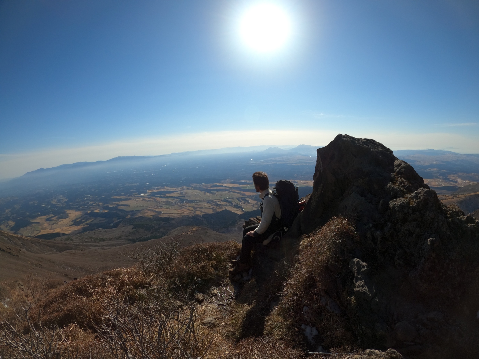
A pleasant breakfast of french toast and coffee the following morning. They seemed to have marinated the bread itself for a long period of time in the cinnamon-infused mixture, leaving the break tasting very fluffy, which was a perfect wake up call for an early start in preparation for Mt. Kuju today.The trail entrance I opted for with Mt. Kuju was the Akagawa trail – which literally translates as “The Red River” trail. As you can see from the second picture here, the water running down from Mt. Kuju itself turns red due to the sulfur/other such volcanic substances in the water, which also renders this water not suitable for human consumption. Either way, I made sure to bring 3L of water for this trip, so that should not be a concern this time, especially considering the round trip was only around 5-6 hours or so.Slowly continuing on from the Red River, snow very quickly began to make itself more apparent, perhaps due to the foliage cover that Mt. Aso from yesterday was lacking. Regardless, the stairs were just about visible, allowing for ascent without the use of crampons, for now.With that said, there were also a number of sections where the stairs disappeared entirely, as pictured above. Fortunately, a number of other hikers had generously left behind trace, making getting lost somewhat impossible.A look back from a vantage point of around 700-800 metres or so. Pictured ahead is the Aso caldera, and Mt. Aso’s peaks Taka-dake, Naka-dake, and the spiky, crown like peak of Neko-dake on the left.Looking back on the stairs here, and by this point I had changed into my 6-spike crampons, due to sections of the stairs, although helpful, being entirely frozen due to the elements. A vantage point further up Mt. Kuju’s trail, this time showing Mt. Sobo and its respective mountains on the left, and Mt. Aso sitting on the middle-right of this shot.Another shot looking off into the distance, clearly highlighting how good the weather was today! Despite being January the temperature was gradually increasing, too.The terrain heading up the path gradually turning more volcanic. Foliage began to vanish, being replaced with rocks/dirt trails instead, becoming incredibly reminiscent of Mt. Ontake from last October. The Mt. Sobo range can also be seen in the distance.Myself at the peak of Mt. Kuju (Not the highest peak, however), 1786m. There were a number of people in this area, so I queued for a while before setting up my GoPro on a timer to be able to take this. (God forbid asking people/strangers for photos…!)A brief descent into a small valley type area looking out towards Mt. Sobo. I was now heading towards Naka-dake (not to be confused with Mt. Aso’s), which is the highest point of Mt. Kuju.A frozen lake on the way to Naka-dake. A number of family type groups were here, likely due to the number of trails that exist leading up to this point, not only the Akagawa trailhead from Taketa city, but also from the Beppu/Oita side too.Looking towards the Kuju peak of Mt. Kuju (Confusing, I know, but that was the peak I took the picture of myself at!)The highest point of Mt. Kuju, Naka-dake – 1791m.Looking off towards Mt. Sobo, tomorrow’s destination, after beginning the descent down the Akagawa trail.
After finishing Mt. Kuju I returned to Taketa city, and winded down in the local hot spring – something that certainly helped considering the two days of accumulated mountain fatigue thus far. After once more confirming the plans for Mt. Sobo the next day with the owners of the hostel, I once more drifted off to sleep in the somewhat cozy bunkbed, a nice change from camping out in the cold.
Breakfast on the third day, Mt. Sobo. The bacon in Japan is always fairly light when compared to stuff found in the west, with the taste being more reminiscent of ham, rather than bacon. Nice, regardless!The quiet path leading up towards Mt. Sobo. Nowhere near as popular as Mt. Kuju or Aso, and this was certainly reflected with the distinct lack of people until at least around 1300m.An intimidating warning left by mountain officials concerning the potential “presence” of bears around the mountain, although it is widely believed that bears in Kyushu have long since stopped existing from a couple of hundred years ago. The skull on the left is meant to be a bear skull, albeit small.Snow present on the trail from a rather early point, although this would have melted by the time I came back down along the same route.Looking back on the trail where stairs assisted the majority of the way following ascending onto a ridge leading to Mt. Sobo’s peak.Around 5 kilometres into the trail, with somewhat desolate looking foliage, reflecting the season, at least! The weather was somewhat questionable, but not unpleasant to the point of rain/snow falling.An intersection around 200m elevation change shy of Mt. Sobo’s summit. It was from this point trace suddenly began to appear, which much like Mt. Kuju likely reflected the popularity of some of the other trails, rather than the one I had opted to take.About 10 minutes away from the summit, with snow levels consistently having been at this level from a good couple of kilometres prior.Myself at the summit of Mt. Sobo – 1756m. There was nobody else at the summit when I had arrived, but I had passed a few people following the earlier intersection I had passed.A rather bleak image looking east towards the rest of the peaks in the Sobo mountain range. Typically in summer it is popular amongst hikers to do ridge walks amongst the whole range, although this is not typically recommended in the winter months due to the extreme variance in weather. A jizo statue (guardian spirit of mountains) wrapped up for the cold, along with an anti-Coronavirus mask left by a fellow mountain-goer. I found the beanie hat fairly endearing.Following descending from Mt. Sobo and spending one more evening in Taketa city, I spent the next day travelling over towards the Kirishima area in Kagoshima prefecture, southern Kyushu. The weather was nice, but also simultaneously indicated that the weather would deteriorate quite badly by the next day, where I was scheduled to ascend Mt. Kirishima, another volcanic series of mountains. This was a footbath that I took advantage of following a few hours of travel from Taketa city to the Kirishima area.
And that just about sums up the first half of my Kyushu adventure in early January. All the peaks were exciting, and certainly lived up to their name of hundred famous mountains, with Mt. Aso in particular being a unique experience due to its evident status as an active volcano. Mt. Sobo, although seemingly not as popular as the first two, was also a nice way to wind down following a rather intense first two days, and the solitude it provided was unique in its own way, especially with it also being an easy-going day trip.
My heartfelt thanks to the owners of Cue in Taketa city, and I would strongly recommend those visiting Mt. Aso/Kuju/Sobo to stop by – they also provide English advice where possible. I’m also considering revisiting in the summer months to give a few of the other peaks of Mt. Kuju a go, I think.
Anyways, that about sums up the first three mountains that I covered in the Kyushu trip, and I will compile numbers 4 and 5 in the next post, with the final entry being an individual post, due to the somewhat unique nature of it (for a somewhat negative reason, but fear not, I am safe!) As always, many thanks for reading, and you can find video footage of the mountains covered in this post here:
Office worker based in Tokyo, Japan. Native English speaker, Native fluency in Japanese (Can translate to a degree). Very large interest in mountains and other nature-abundant areas, and also my blog's namesake.
View more posts