Hello again everybody, Alex here. I thought I’d finally get around to updating this with a couple of mountains that I did back at the start of December – beginning with a trip out to “The Golden Ridge” series – three of the Hundred Famous mountains of Japan – Mt. Mizugaki, Mt. Kinpu, and Mt. Kobushi (甲武信ヶ岳). The latter is quite a distance away from Mt. Kinpu, so that will be included in the next post with Mt. Kinpu, which I completed both on the second day. This trip overall took two days in total, with the second day being a rather colossal 18 hours or so in total, and not exactly something I’d recommend for the sane of mind!
Anyways, concerning Mt. Mizugaki which will be covered here, it is 2,230 metres elevation, with an approximate 1,000 metres or so elevation change from the trail head entrance that I chose to start from this time. The trail head of choice was the Kuromori trail (黒森登山口) – lying to the West of Mt. Kinpu, which takes an approximate 5 hours or so to the summit of Mt. Mizugaki. Before this, however, I chose to access the trail head itself from the somewhat distance Shinano Kawakami train station (信濃川上) to the Northwest (a good 12km or so away) – which I covered in around 2 hours due to (thankfully) most of the road being flat. As such, the starting time, although a bit later than I would have hoped for, was around 10AM.
As for some information on Mt. Mizugaki, it is fairly unique as far as mountains go, distinctive for its unique composure of granite, resulting in a rather unique looking summit, which should be visible in a few of the pictures below. Additionally, due to the numerous rocky outcrops, it is sometimes seen as a holy grail of sorts for rock-climbers – somewhat akin to how Mt. Tsurugi of the Northern Alps (剱岳) has a similiar status due to its chain climb sections. Finally, although I’ve dubbed this “The Golden Ridge”, Mt. Mizugaki is officially part of the Okuchichibu Mountain Range (奥秩父山地・山塊) – which is a huge mountain range covering the Western portion of Tokyo, expanding into Gunma, Yamanashi, and Saitama Prefectures. As the range itself is so large I won’t extensively list all the mountains here, but some that I will cover in this series include: Mt. Mizugaki, Mt. Kinpu, Mt. Asahi (朝日岳) Mt. Kokushi (前国師岳・国師岳), Mt. Kobushi, as well as Mt. Kumotori (雲取山) – (Another of the Hundred famous mountains that I had initially planned to include in this trip, but left it out for a separate occasion).
A “very” approximate, (badly) drawn map of my chosen route this time. The starting point of Shinano Kawakami train station is the circled X on the top left, taking the long road down to the start of the Kuromori trail entrance, then leading to the first X of Mt. Mizugaki at 2,230m. Following a quick descent of around 200m that marked the first camp spot at Fujimi-daira (富士見平). After this the second, long day would begin, with a brief traverse over to Mt. Kinpu at 2,599m, then a long(ish) trip up to Mt. Kobushi, then a fairly easy-going descent down towards Nishizawa-Keikoku (西澤渓谷), ultimately finishing the second day at around midnight following a 0400AM start. The large circled red area loosely covers the Okuchichibu Mountain Range, which is mainly comprised of the Chichibu Tama Kai National Park (秩父多摩甲斐国立公園).
As always, I think that’s enough prelude information, so I will go over the trip in a bit more detail in the pictures below! I hope you enjoy, and I’ll leave a little comment below as a conclusion of sorts before getting to work on part two of this series!
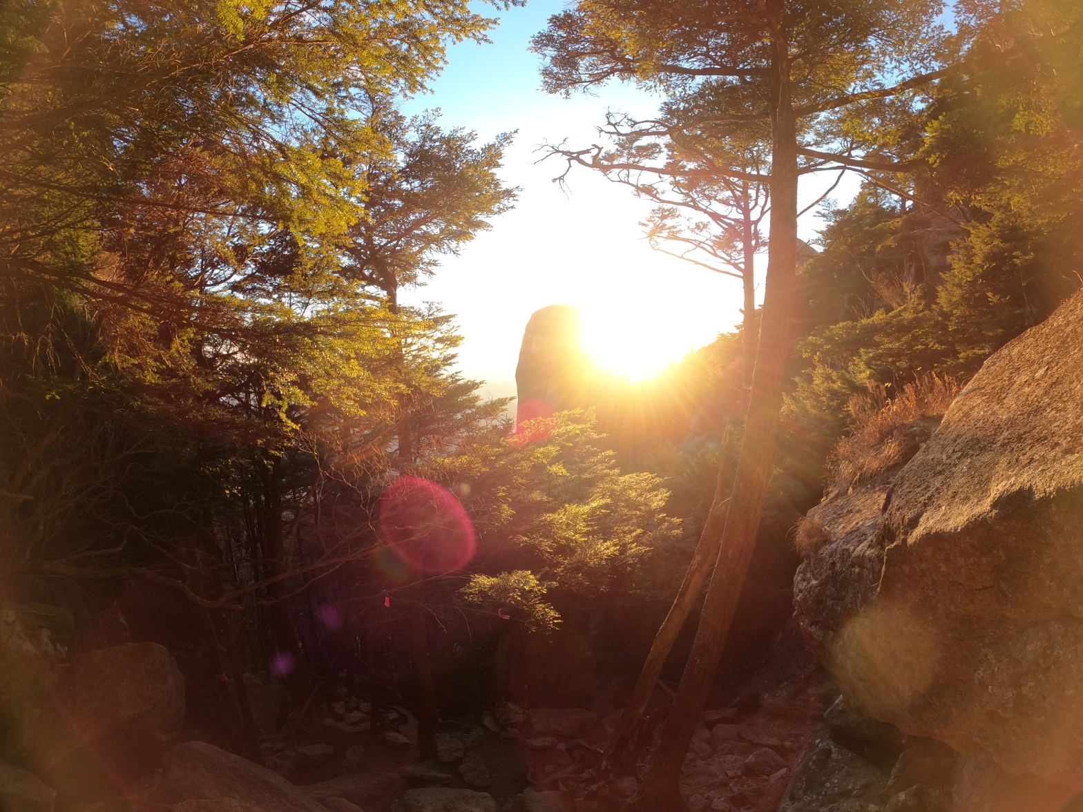
A sunny start to the day after getting off the train in the remote town of Shinano Kawakami – a quiet, quaint town that seems to necessitate having a car to get around due to a visible lack of public transport. This was taken facing towards the Western outlying parts of the Okuchichibu Mountain range, and I would continue South from here for a good two hours under the morning sun, which fortunately was not too uncomfortable due to the December air being fairly refreshing.Continuing on down South, about 6km after the previous shot, in the middle of nowhere. The mountains in the distance made up the beginnings of the series of peaks quite near Mt. Mizugaki, indicating that I’d certainly made some progress so far. Judging off the sun, the time was around 0900AM or a bit after that in this shot.Moving from Nagano prefecture from where I started into Yamanashi prefecture, where our destination this time lies. I don’t imagine one is meant to walk this route as I didn’t see a single soul on this entire leg of the journey, but the solitude was certainly quite nice!Although not the best picture from a distance, that rocky outcrop in the centre of the shot in the distance is in fact Mt. Mizugaki’s peak – fairly distinctive from the surrounding peaks thanks to its granite make-up! I thought it was fairly impressive that I could get this clear a shot from this distance, considering that Mt. Mizugaki isn’t exactly colossal in size, and I was still a good 10km away or so from this point!Now entering into “Mountain” territory so to speak, the main road from before vanished, and transformed into a mountail trail of sorts. I believe one could access this via car when I went, however it may be closed during periods of the Winter that may be unbeknown to me. Either way, after entering onto this section at around 10AM or so, this path/road would continue on for a good hour/hour and a half or so.After entering into the Kuromori trail head proper, I finally got to start hiking up an actual mountain trail, which made a nice change from the roads that I had only experienced thus far. This picture shows a somewhat scary part though, where due to a bridge having collapsed here before, hikers instead had to do a log walk over a (rather slow flowing) river with the assistance of a flimsy looking rope on the side. Certainly doesn’t hold a candle to some of the terrifying sights of the Northern Alps for sure, but still an interesting experience, especially with a 20kg bag on ones back!Signs of winter approaching, with the river beginning to freeze in places. Heading into January, I’m sure this will likely all be frozen. “Fudo Falls” (不動滝), or what remains of them currently due to the Winter season having begun. Although conjecture, I imagine this would be much more impressive looking in the warmer months, and one can tell from the erosion of the rocks that there is normally a lot more water content here than I captured in the picture. Still, rather quaint.Beginnings of snow on the trail, at around 1,900m elevation, at 1400PM or so. Due to the Kuromori trail winding around the Eastern side of Mt. Mizugaki, there would not be much exposure to sunlight here, likely explaining why there was only snow on this portion of the trail, rather than the Western side, which would bear the brunt of the midday/afternoon sun.A brief respite in a small clearing just prior to the summit of Mt. Mizugaki. I was blessed with clear blue skies for the entirety of the day, which I was incredibly grateful for, because even with the weather as good as it was, it was beginning to feel slightly chilly being in the shade all the time! Onwards and upwards!The summit marker of Mt. Mizugaki, one of the Hundred Famous Mountains of Japan, standing at a considerable 2,230.2m tall. I summitted around 1500PM or a little thereafter, which allowed for some stunning views of the late afternoon sun over the West.Exhibit A, the sun blazing of the West, with Mt. Aka (赤岳) of the previously explored Yatsugatake range poking her head out on the right hand side of this shot in the distance. Staring wistfully into the distance, and although not captured in this shot, Mt. Kinpu was just left of the mountains in the distance that I am looking towards. There was a rather scary drop just below where I was sitting, so I didn’t dare take any footage/photos from that vantage point!A somewhat small passageway that I struggled to fit through… Possibly not designed with large people in mind…A shot of the sun sinking down that I took on the descent down towards Fujimi-Daira. The rocky outcrop in the centre of the shot is also possible to be scaled by the aforementioned avid rock-climbers, but I wouldn’t personally recommend it, given that it looked to be a good 200m of vertical ascent…“Dangerous. Don’t grab the rope” – an ominous sign whilst descending in the dark. There was a slight drop to the left of this shot, but other than that I still can’t quite figure out what makes this so dangerous…?Setting down camp at Fujimi-Daira at approximately 1800PM. The temperature had also dropped down to around -5 degrees at this point, so I took the executive decision to have my meal inside for once, rather than unnecessarily exposing myself to the elements. Cup noodles, walnuts and protein bites were on the menu for tonight, and they were very tasty. I also noticed my gas was struggling to stay alight at times, showing signs that I needed to likely switch to a propane-based gas in the future for further Winter expeditions on account of the cold.
And there we have it. Following my meal, I had an early night, in preparation to set off at 0400AM the next day, which would turn out much more differently than I had anticipated on account of the weather. I will leave that concluding thoughts of this, and the other mountains I covered for the next post where I will sum them all up together as an experience, so look forward to that!
Office worker based in Tokyo, Japan. Native English speaker, Native fluency in Japanese (Can translate to a degree). Very large interest in mountains and other nature-abundant areas, and also my blog's namesake.
View more posts