Hello again everybody, Alex here. Once more I decided to foray into the Northern Alps of Japan once more in 2020, this time setting my sights on two mountains on the same ridge line in the Northeastern part of the Alps: Mt. Shirouma and Mt. Goryu (五竜岳) those being 2,932m and 2,814m respectively. I planned this out as a total of three days, and whilst I had initially planned to continue on down to another Hundred Famous Mountain, Kashima Yarigatake (鹿島槍ヶ岳), I decided against it following the mammoth second day that took a total of 14 hours!
As for Mt. Shirouma and some history, the name itself is often a topic of debate, as the Kanji characters 白 (Shiro) and 馬 (Uma) (Literally, white horse), can also be read as “Hakuba”. Some buildings, such as the train station and even the lodge that I stayed in on the first night also have the same “Hakuba” namesake, which often leads to some confusion, even among native Japanese individuals. However, after some quick research on the Japanese end, the name itself is originally from different Kanji characters all together (代掻き馬) → (Shirokaki-uma) (Literally refers to how the snow/rocks appears from the mountain during the spring months), and following some evolution of the Japanese language changed into the namesake/reading that we recognise today.
Secondly, Mt. Shirouma is known for a quite unique phenomenon: that is, the “Deep Snow Gorge” (白馬大雪渓), which is a valley of glacier-like snow that never melts throughout the year. In scientific terms this is known as a Firn, and are often found within Northern European countries where snowfall is a common occurrence. I am not exactly qualified to describe firns in detail, but as far as I am aware, the snow within firns and the Deep Snow Gorge by extension is incredibly dense, which allows for it to stay in existence, even through the scorching Japanese summers. Unfortunately on my journey this time the Deep Snow Gorge was blocked off from access due to some danger within the valley itself (from what I gathered from the lodging staff, there was both risks of falling through certain areas of the snow [crevasse], as well as potential mini-avalanches).
A picture of Shirouma Dai-Sekkei, presumably at some point during the peak hiking season, courtesy of Japanese Wikipedia.
Although short this time, that about sums up what you need to know about Mt. Shirouma, so I will get into my journey this time, which started at the crack of dawn on Saturday morning, following staying a night at the relatively nearby Matsumoto City (松本市) in Nagano prefecture (長野県). With that, I’ll let the pictures and captions do the rest of the talking, and see you for some after thoughts later!
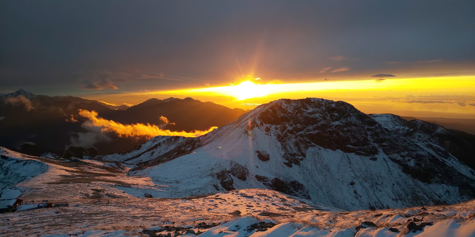
The first train on the top left towards Shinano-Omachi from Matsumoto city which I had stayed in the night previously, then transfering trains onto a “One-man-train” heading towards Hakuba-Oike (白馬大池). I was scheduled to arrive for around 0800AM, followed by an hour walk towards the ropeway station, which I was rather concerned would be incredibly congested, as I had read some horror stories on the internet about the wait at the ropeway taking upwards of 2 hours…Fortunately the wait for the ropeway took a brief 10 minutes or so, with the majority of the other clientele seemingly there for autumn leaves viewing, as I was visiting on the tail-end of the autumn leaves period. The ropeway station that I took was called Tsugaike Ropeway (栂池), and is infamous at certain periods of the hiking season for being practically un-usable due to congestion.800 metres later, I started from the hiking trail, with a fairly long 6/7 hour one way hike ahead of me, in expected snow conditions. The starting elevation, if I am remembering correctly was approximately 1829 metres, which left an elevation change of approximately 1,100m towards the peak of Mt. Shirouma, with some ups and downs on account of the couple of peaks prior to our end goal. The weather was unfortunately incredibly grim from the start, with a substantial amount of rain making itself conspicuously known. A damp start, to say the least. Before long, however, the rain soon turned to snow, which was a bit more pleasant than being rained on constantly. The path upwards was not particularly well maintained, however compared to Mt. Ontake’s stairs and the state of disarray they had fallen into, this was much more bearable. I did not come across many people on the hike up, possibly because they were staved off from hiking on account of the bad weather, despite it being a Saturday.After an hour and a half of hiking, I reached the first checkpoint, Tenguhara (天狗原), which served as a, what I imagine to be, a viewing area. Unfortunately heavy cloud cover was settled around this area at the time lowering visibility to around 20 metres or so, but I did come across a French family, who appeared to have brought their two children along to enjoy the snow in mid-October. A pleasant family outing, I’m sure. The boardwalks around Tenguhara were very well maintained, too, despite the rather heavy snow that had decided to settle on them.Continuing on for a good hour or more and a few hundred more metres gained following Tenguhara up rocks caked in snow, I came across the second checkpoint, Hakuba-Norikura, which shares a namesake with another Hundred Famous Mountain to the south of the Northern Alps, Mt. Norikura (乗鞍岳). Alas, once more, little to no visibility here!My first “view” of the day an hour or so after Hakuba-Norikura, of a large lake at the foot of the ascent eventually leading up to Mt. Shirouma. As an additional piece of information, the train station that I started from, Hakuba-Oike, means “Hakuba lake”, so I can only assume this is the lake that the namesake is referring to. Very wide, this took around 40 minutes alone to navigate around, and the cloud cover rolling in and out obscuring vision here and there added to a sense of serenity I felt by myself.After passing a rare instance of lots of humans gathered together at a mountain lodge near the lake having lunch together, I continued my solitary path into the cloud cover once more, heading up the ascent towards the collection of peaks that would eventually end in Mt. Shirouma. Fortunately there was no wind today, as by this point the fake-fur on my hat had already begun to freeze over as a consequence of the rain from the lower elevations. Wind, I could imagine, would have made this journey a whole lot more unpleasant. Visibility worsens, with cloud cover restricting my field of vision to about 10 metres or so. This certainly slowed down progress as I did not wish to go tumbling down a snow ridge a la Mt. Tsurugi style once more, but perhaps was a saving grace as I did not end up exhausting myself too much, as I often end up doing on other peaks!Reaching another peak leading towards Mt. Shirouma, Funekoshi-no-kashira (my reading of this may be wrong, apologies). Elevation was around 2,600-2,700 metres I believe, which certainly acted as some strong motivation to continue onwards, despite the dreary conditions.Sweeping views of the North from Mt. Korenge (子蓮華山), with the Japanese Sea ever-so-slightly in view. The summit marker of Mt. Korenge. I nice episode that occurred here was that I happened upon two other hikers (a rarity for today for sure!) and as well as sharing conversation, we also all had some Cafe Latte together, which helped to keep us warm in the biting wind that was making its presence known. The temperature was around -3 degrees celsius at this point, so I also gave both of them a disposable hand warmer packet, one of the useful pieces of equipment that I carry spare in cold-weather hikes!After moving on from Mt. Korenge, the cloud cover once more rolled in, and I took this rather dramatic picture of me facing off Mt. Shirouma’s final approach.Looking back 40 minutes later, this sweeping landscape greeted me, and I remember muttering at the time as to why I could not have this view when I was actually climbing, rather than perpetual cloud cover!! Despite that, this view certainly made up for it, and despite the cold I took in how much I had traveled thus far, and pressed on with renewed enthusiasm.The final, final ascent of Mt. Shirouma (for real this time!), with hints of the sunset appearing on the right-hand-side, putting the time at around 17:15 here. You can also just about make out some people on the summit of Mt. Shirouma in the left of this shot.Finally finished! Through thick and thin, I finally summited at approximately 17:30, and set up a timer on my camera to take this picture with the sunset slowly appearing in the background. Still incredibly cold in this picture if you can’t quite tell!!!No words needed really. The sunset taken from just 20 metres below the summit of Mt. Shirouma, elevation around 2,900m.Myself surveying the landscape before me. (Those of you with sharp eyes will recognise the triangular peak on the left hand side as Mt. Tsurugi, the mountain that maimed me 4 months prior to this!)Another sunset shot. I really liked how the snow radiated a red sort of hue with the sunset.A final sunset shot, with the sun disappearing 5 minutes or so after this. As a result, me and the two other friends that i had made earlier back at Mt. Korenge quickly made our way down to the mountain hut (白馬山荘・Hakuba-sanso) which was only a 15 minute descent away, about 100 metres lower elevation that Mt. Shirouma’s summit.A rarity on my mountain adventures, but a warm, wholesome dinner!! The rice and miso soup also had free refills, so I certainly took advantage of that to make up for the lack of eating that I’d unfortunately done during the day. Following this I purchased a pin badge to commemorate my ascent. Other than that I prepared my bag for the next day back in my, admittedly, rather cold room!
And that’s the end of the first day of my return trip to the Northern Alps, with Mt. Shirouma ticked off this time! Although the weather was certainly up and down in terms of cloud cover, I can honestly say that the sunset at the end of the day definitely justified getting up at 0500AM to get on the first train towards Hakuba-Oike. In retrospect it would have been wiser to attach my crampons from about 2,300/400 metres onwards, but this is certainly a lesson learned for next time, and as I did not end up falling there was no harm done.
Mt. Shirouma, and the route that I took this time from Hakuba-Oike is probably impossible to do as a day trip, as the single-way journey itself took a good 7/8 hours, and that was after using the ropeway system to start from a higher elevation. At least one night is required at the peak should one be wishing to summit this beautiful mountain, and I would recommend taking advantage of either Hakuba-sanso or one of the other mountain lodges via the other routes when they’re open to sample some of the food!
Either way, after a sleep at Hakuba-sanso, the rather large journey towards Mt. Goryu awaited me, so I made sure to get an early night, setting my alarm for an early, 0300AM start…
Office worker based in Tokyo, Japan. Native English speaker, Native fluency in Japanese (Can translate to a degree). Very large interest in mountains and other nature-abundant areas, and also my blog's namesake.
View more posts