Hello again everybody, this one has been on the backburner for a while, so I finally decided to write it up! This time I decided to go to Mt. Ena, which is technically part of the Central Alps (中央アルプス) group of mountains, making this the third and final mountain of the Central Alps for me to conquer. Interestingly although Mt. Ena is technically a part of the Central Alps, it is separated from the ridgeline that connects Mt. Kisokoma and Mt. Utsugi, with a fairly large road and railway separating the two groups of mountains.
Mt. Ena stands at 2,191 metres elevation (around 7,200 ft.) tall, with an elevation change from the Hirogawara trail head (広河原) being around one thousand metres, give or take. Mt. Ena, although not particularly vertically tall, is incredibly large in terms of distance needed to be able to access, so it has 4 separate trail heads, they are as follows:
Maemiya Trailhead (前宮ルート) [Starts at approximately 600m] [https://www.yamarepo.com/100/enasan.html details of the route in Japanese, with a map] – accessed from the West/North-West – this route is supposedly infamous for taking an obscenely large amount of time (7/8 hours)
Misaka Pass Trailhead (神坂峰ルート) [Accessed following a ropeway, elevation likely similar to Kuroisawa and Hirogawara start points] [https://yamahack.com/guide/64 details the starting area/access in Japanese] – Appears to start from the North-West, further North than Hirogawara’s start point.
Unlike a lot of the other mountains that I’ve done so far, I could not find any notable religious background to Mt. Ena, but I would not be surprised if it was also religious, probably tied to either Shintoism or Buddhism. The multiple trailheads suggests that there is probably a pilgrim route of sorts, which typically indicates a religious background of sorts to Japanese mountains.
Anyways, as always I will leave some pictures below with captions guiding you through the day. Many thanks as always for reading, and I’ll see you below with some after thoughts.
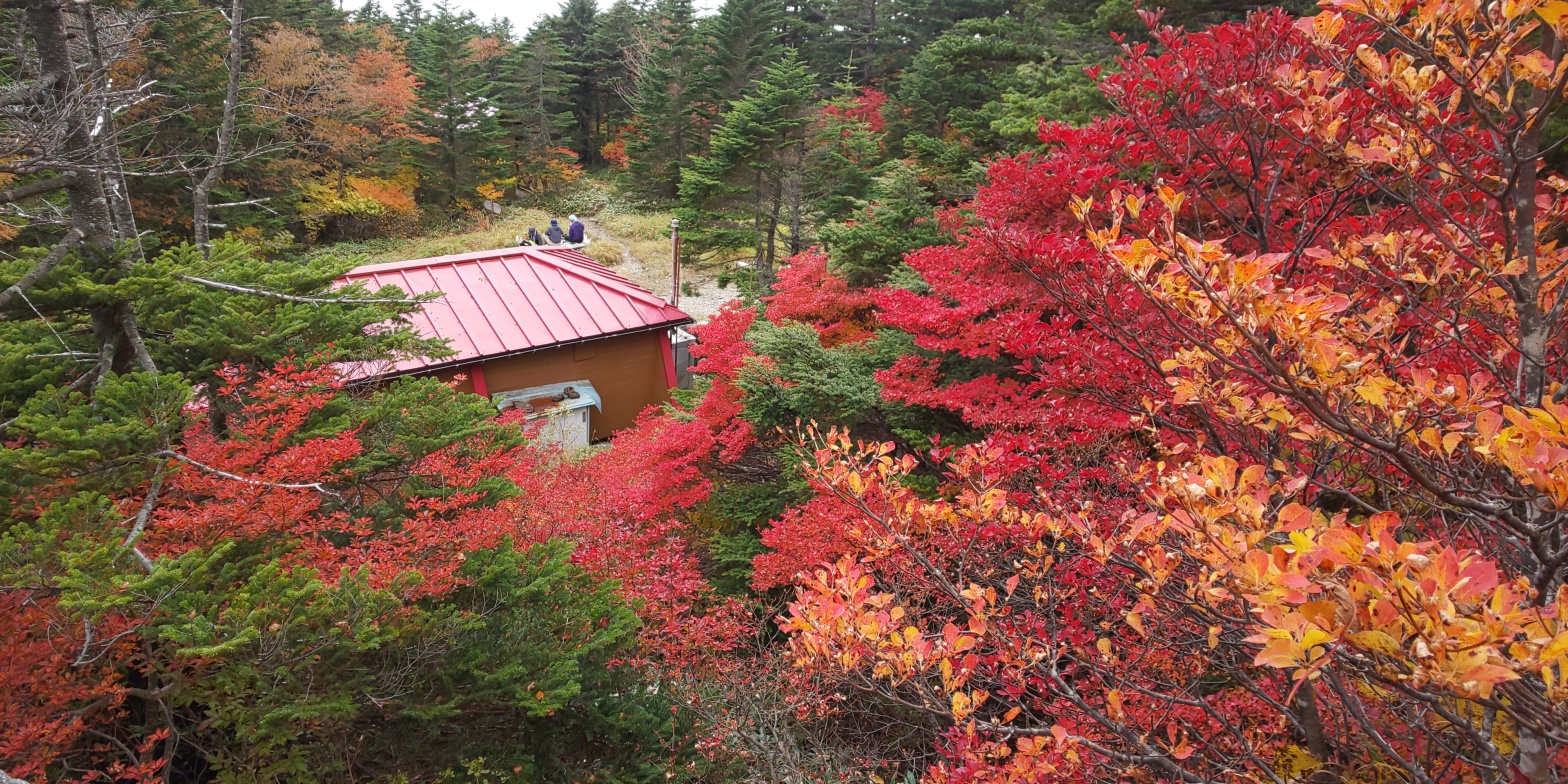
The starting point for today’s hike. I got a lift with one of my friends that I made at Mt. Ontake (御嶽山), so we started from the car park on the North-Eastern side of Mt. Ena. We got there fairly early (approximately 09:30), however as you can tell the car park was already fairly busy! From here a gradual uphill walk along a footpath to the trail head awaited us, which would take around 40 minutes at a leisurely pace.The pillar looking object in the middle of the shot is where people submit their “登山届” or “Mountain climbing reports”. These are not exactly a legal requirement, but the idea is to submit them with a plan of your hike, how long it will take, and when you plan on returning. For a bit more background, I believe that unless you submit one of these, certain insurance companies can wriggle their way out of covering you for any misfortune that may occur on the trail, so I would highly recommend submitting one of these any time you go on a mountain trail in Japan! (There is a wide-spread belief that these are not read, but I can say from experience that following my fall from Mt Tsurugi (剱岳の方), my mountain climbing report was fished up from when I submitted it the day beforehand!)Crossing a river just prior to the beginning of the trail head. The ladder was fairly rickety – so I briefly had images of the bridge breaking and falling in for a rather sudden dip! It was also nice to be able to have the chance to refill my water here, as I’d neglected to fill up my platypus entirely prior to departing for the day.The beginning of the trail head began as a progressively winding forest path, that had a multitude of switchbacks, resulting in a relatively steep elevation gain for a little amount of distance walked. We entered the trail head at around 10, 10:15am, and also took note of the trail markers, of which there appeared to be 10 in total for the whole course (with, which I may add, were incredibly deceptive in terms of accurate distance measuring!)The sun peeking through the tree tops. The weather at this point was perfect, albeit a touch hot, however the trees provided a nice amount of shelter for the majority of the first part of the journey. Elevation-wise, this was around 1700-1800 metres, with the tree level on Mt. Ena extending all the way to the summit of 2,191m.A nice sweeping shot of what I believe to be Mt. Ena’s “summit” from a distance, enveloped in autumn colours. Although I didn’t think much of it at the time, the cloud cover was rapidly beginning to come and go, providing an omen as to what was to come later on in the afternoon.Overlooking the surrounding mountain ranges as seen from Mt. Ena. In the distance to the left (not in shot), would be the Kiso Mountain range, where Mt. Kisokoma (木曽駒ケ岳) and Mt. Utsugi (空木岳) reside. The time of this shot was around 12:15/12:30, so approximately 2 hours after beginning the hike.A shot of the progressively thinning tree cover as we proceeded to higher levels of elevation. In the shot you can see two of my other travelling companions, as unfortunately one of the other people with us had pulled his leg, and decided to descend slowly back to the car park by himself. Additionally, as foretold earlier on by the looming cloud cover, you can probably tell in the top of this shot that overcast weather had very quickly taken hold over the top of Mt. Ena. Regardless, we pressed on, determined the get to the summit and make a quick evacuation before any ill timed rain decided to make itself known…At around 13:00 we reached the summit of Mt. Ena! The weather had certainly taken a nose-dive to say the least, but the autumn colours at the top were very pleasant, and we certainly came across a lot more people at the summit as the three or four hiking paths leading up to the summit all converged on one another. We proceeded on towards the mountain hut at the summit to have a spot of lunch, and this shot was very pretty I thought! We seemed to have come at just the right moment concerning autumn colours, as you can tell from the blend of reds, oranges and yellows. (The red mountain hut blends in quite well, too!)A bit more of a wide-framed shot that encompasses the red colour range at the summit’s mountain hut. The weather was continuing to get progressively more grey as we were taking these pictures too…Not a single sight in view this time, certainly a different landscape to the same angle an hour earlier! We began our descent shortly after the previous shot, and as the elevation dropped, there were some signs that we were starting to drop below the cloud level, which was somewhat reassuring! This was a similar angle to the shot I had taken earlier on in this post, but as you can tell, this one was fairly obscured by clouds, still…About a hundred metres further down or so from the previous shot…… And about a minute after the previous shot! The clouds were beginning to slowly roll up towards the summit, granting us another sweeping view of the surrounding landscape and mountains.Another 100 metres or so later, this was pretty much the same angle from the shot earlier where the sun was blazing down, this time covered with rather inconsistent cloud cover. After descending later on, we took a small detour to a local gift/coffee shop, and once more the weather had taken a positive change, granting some sweeping landscapes with the mountains and sky in harmony with one another. Additionally, we saw a snake carrying a frog in its mouth across the road on the way here (no picture, sorry!), which was certainly an interesting experience…A cup of matcha, with a Japanese sweet, and my new mountain badge depicting Mt. Ena! Although I’m typically someone who likes to have a hot chocolate after a mountain, some Matcha also did the trick, I found!
And that’s that! Mt. Ena was a lot kinder than some of the mountains in the Hundred Famous Mountains collection I’ve done so far, but that isn’t to say it was a cake-walk in the least! The elevation change was a good thousand metres or so, making it more difficult than some of my local mountain in Kyoto, and the unpredictable weather exacerbated some of the difficulties, I imagine. There was a lot of mud on the trail as an after-effect of a recent typhoon, which certainly slowed down progress/the descent, but that aside conditions on the ascent were perfect. The descent was blighted by overcast weather, but fortunately visibility on the trail itself was not an issue at all, making this an easy day-trip if accessed via car.
I unfortunately can’t vouch for any possibility of doing this via public transport as a day trip, although there is a mountain hut at the top (unmanned), should the ambitious hiker wish to try accessing via the Maemiya trailhead, which appears to be walkable from Nakatsugawa city (中津川市). Be prepared for a rather long journey though, as that route seems to be considerably longer than the Hirogawara course, even though the latter was fairly long itself!
Mt. Ena was enjoyable to do as a group trip, and I’m glad to have finally gotten it out of the way, having passed it many times so far when on the way to the Northern or Central Alps in the past. Next on my agenda is one final venture into the Northern Alps for 2020, with Mt. Shirouma and Mt. Goryu being my targets this time. There will be some early signs of snow, so I’ll take extra care this time, but please look forward to that in the meantime!
As always many thanks for reading, and I’ll see you next time!
Office worker based in Tokyo, Japan. Native English speaker, Native fluency in Japanese (Can translate to a degree). Very large interest in mountains and other nature-abundant areas, and also my blog's namesake.
View more posts