Hello everybody, this is one of two mountains that I climbed this weekend, so we’ll start with the one I did first: Daisen, in Tottori (鳥取) prefecture (Northwestern Japan). Daisen literally translates to “Great Mountain”, or “Big Mountain”, and not surprise at all, it is incredibly integral to religious sects of Buddhism within Japan (As well as potentially Shintoism). It’s tallest peak (Kengamine/剣ヶ峰) stands at 1,729m tall, however due to an earthquake that hit the Tottori area in 2000, the peak is on the verge of collapse, and access to it is strictly prohibited for the time being. In lieu of this peak, visitors can hike up to the second highest peak, Misen (弥山), which stands at 1,709.4m tall.
For some brief history on Daisen, as previously mentioned, this mountain, as with many others that I have visited up until now stand integral to the Shugendo sect of Buddhism in Japan. An easily understandable explanation of Shugendo in a nutshell can be given as describing the practitioners of the sect as so called “Mountain Monks” who dedicate themselves to a life of asceticism, often with rather grueling training rituals to be initiated “properly”. Prior to 1000AD Daisen was often referred to as the most important mountain among all Shugendo-associated mountains, with it often being given the name “Mountain of the Great God”. The shrine located just near the trail entrance, Ogamiyama Jinja (大神山神社) can also be seen to have its namesake from this tradition, with the shrine’s name literally being translated to “Shrine of the Mountain of the Great God” (A mouthful, for certain!)
For some geographical history, Daisen is thought to be approximately just shy of 2 million years old, which is when eruptions were thought to have started occurring. Following these eruptions, “Old Daisen” was formed 500,000 years ago, and from the caldera “New Daisen”, or the Daisen that we know today was formed around 450,000-490,000 years later. Comparatively speaking to the likes of Mt. Aso in Kyushu (阿蘇山), Daisen is relatively new if one looks at “New Daisen” exclusively, however it is now thought to be inactive, hence its status as a “Volcanic mountain”, rather than “Active Volcano” such as Mt. Ontake (御嶽山) or Mt. Aso.
As always, thank you for reading so far, I will paste some pictures below to guide you along my two day trip to Yonago city, then Daisen the following morning below. I was rather anxious concerning the typhoon that had been scheduled to hit Japan, but as I would find, the weather would not be “too” punishing.
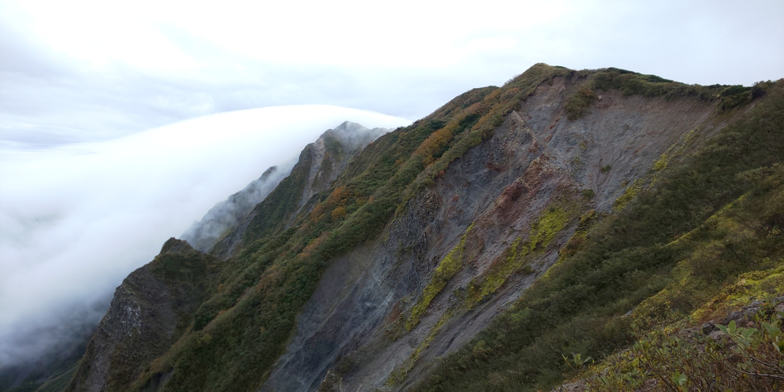
I arrived in the city of Yonago (米子市) in the evening (7pm or so), and discovered my hotel with a hot spring was a 6km walk away – not wanting to miss out on some extra steps/exercise I decided to take the walking option rather than ride public transport as I’m sure any other person with some vestiges of common sense would do! I thought this structure just outside Yonago station was quite pretty, and decided to take a quick snap of it. There were many businessman-looking types taking pictures next to it, so I waited patiently before taking my picture, just in case some of them were adverse to being snapped by me!After checking in at the hotel and having a relaxing rest in the hot spring at my hotel, I took a little venture out to the nearby coast of the Japan sea, which was a brief 5 minute walk away. This was my first time seeing the Japan sea in person, and although I had heard stories of it being fairly choppy, the typhoon passing over seemed to make the waves crashing against the shore that much more intimidating. It’s probably also worth mentioning that I appeared to be the only one out for an evening stroll, despite it only being 21:30 or so at the time, so maybe others were heeding their survival instincts and staying inside away from the rather strong winds… Anyways, after taking a few mediocre pictures I turned in for the evening, enjoying a fairly deserted hotel with a Japanese style private room.The next morning on the way to the station, with signs of the typhoon seeming to have abated somewhat. Approximately 07:10 in the morning here, although there were signs of Yonago city beginning to wake up. On a clear distance, one would be able to see Daisen looming in the distance, but some clouds consistently decided to block the view for most of the morning, thwarting my efforts of capturing a picture.After catching the bus (and briefly panicking about whether the bus was even running or not), I arrived at the rather holy site of Daisen temple, which seems to have become somewhat of a tourist spot in recent years at around 08:30 in the morning. I was, unfortunately speaking, greeted by rain immediately upon arrival, so took shelter with a few middle-aged men near a toilet, and shared some conversation with them about what they were doing there today. They all seemed to be intent on ascending Daisen, but shared the sentiment that when rain came pouring down, one’s motivation also took somewhat of a hit. I agreed, but continued on uphill towards the main temple, where I hoped I would find some sort of entrance to Daisen’s trail head – the multitude of souvenir shops and tourist attractions were certainly throwing me for a loop and leaving my sense of direction in somewhat of a shambles…Looking back down the path which I had ascended, which I would hazard a guess at around 100-150 metres, leaving the elevation at this point at approximately 600-700 metres, if my elevation tracker was anything to go off, anyways! The rain was beginning to ease off a bit at this point, which was fairly pleasant. About 10 minutes after the previous shop, I finally came across the “Great Mountain Shrine” of Daisen, which I had assumed was where I would find a trail head of sorts. The shrine holds an opening ceremony for Daisen every July, marking the beginning of the hiking season. As far as I discovered, this was Buddhist of origin, but there could be other, Shinto-based shrines, elsewhere at the base of Daisen.Finally, a trailhead marker! 3 kilometres is marked as the distance to the summit, although quite frankly I’ve learned to take these directions with a pinch of salt, as quite often they do not take into account distance travelled that is not perfectly linear from marker to marker (excludes any winding mountain roads or switchbacks for instance). Either way, this acted as a nice bit of motivation, as at least I knew I was on track now!The eerily quiet mountain path beginning from The Great Mountain Shrine – this path was named “The Pilgrim’s Trail” – so I doubt this needs any explaining. Alas, I did not come across any pilgrims, or even wildlife for that matter, so was alone to myself for the next 40 minutes of walking.This, I imagine, was once upon a time a river bed, but now is dried up, for what I imagine to have been for many hundreds or even thousands of years by this point. I also imagined it could have been a volcanic flow-point at some period of history, but seeing how there were dam type structures built in place, perhaps both of my theories were off the mark. On a clear day one would be able to see Daisen’s peak jutting out in front of us from this shot, but some cloud cover decided to get in the way, denying that opportunity. Instead, we were left with a rather eerie looking scene, especially considering I was still the only presence on the trail that I had encountered up until this point. I continued on to the right following this shot and briefly got lost accidentally following a dried up riverbed, but eventually found my way to the mountain trail once more, beginning an incredibly steep ascent up to Daisen, which I predicted would take the better part o 2 hours from this point. Holy moly! An elevation marker! I love seeing these, honestly. Perhaps because for the last 4 or so mountains I’ve climbed there has been no indication whatsoever on the trail concerning what height you’re at, only an overly ambiguous estimation of “remaining time to the summit”. I always find elevation markers help with the psychological struggle one often experiences on the trail, and also puts an “x amount left to the top” in your head, rather than a time estimation. Either way, only 500 or so metres to go from this point!But alas, most of the climbing was done with stairs, which I certainly have a love/hate relationship with. Although they may get you from point A to B “quicker”, I honestly find myself getting incredibly exhausted very quickly with stairs, if compared to rock navigating/using chains – as is often the case with the Northern Alps… Either way, no use complaining! Onwards and upwards! (The rain did not help particularly with navigating the WOODEN stairs either, so this ate up a substantial amount of time).Stellar views as a result of some stubborn cloud cover that appeared intent on obscuring any views from Daisen. On a clear day one would be able to see the Japan sea and Yonago city in the distance, but I would be in for a surprise later on concerning that! (Estimation at this point approximately 1,500m)Oh, what’s this? A view of sorts! Looming in the clouds in front of me was one of the minor peaks of Daisen, finally making its appearance for the first time today as a result of the clouds beginning to thin out as I ascended more and more. The sun was beginning to make its presence known too, for the same reasons. I eventually broke through the cloud level at around 1,600m – and was greeted by this mini sea of clouds (雲海). It was slightly frustrating to see that the cloud cover was ONLY covering the area of the hiking trail, whilst the surrounding areas were seemingly cloud free! This view certainly acted as even more motivation to continue climbing further up, and even better was that the wind that was perpetually making its presence known within the clouds had also abated as soon as I’d broken through the cloud cover, which allowed me to take a short respite before continuing on.Another view of the cloud levels seen, about 20 metres or so up from the previous picture. A before…… and after shot of the Northern face of Daisen, which was being continually assailed by clouds rolling in and out at a level that is better captured through video format! The big peak in the distance slightly obscured by clouds is “Kengamine” – or Daisen’s tallest peak, that is currently off limits as a result of damage sustained during the Tottori earthquake of 2000. Our target objective is instead to the right of it in this shot, Misen peak. The colours of autumn were also beginning to make themselves known on Daisen, and I’m sure if I had come a couple of weeks later, they would be in full bloom.A lovely surprise upon reaching the plateau at the summit of Daisen – a boardwalk! This certainly beat navigating rocks or stairs to Misen peak, and was also placed in an effort to preserve the surrounding wild life, I imagine! A look back down the boardwalk to Misen peak over the sea of clouds. Yonago city is in the centre of the shot, with the Japan Sea also in clear view. It was hard to imagine being able to get these views at the top when I first started this hike 2 hours ago! Although slightly lackluster, this is the summit marker point of Misen peak, Daisen. I’m also in the shot, but looking somewhat dreary as a result of being rained on within the cloud cover earlier… As you can probably tell from the shot, the cloud cover overhead was rapidly changing and becoming more and more grey, so I tried to keep my time at the peak as short as possible, to avoid the risk of precipitation once more…Whilst at the summit a kind man also gifted me two of these sweets. They’re similar to the tough caramel-type Cadbury’s chocolate eclairs (not the cream filled ones) back in the UK, so they were certainly a nice recovery snack at the peak! I also exchanged some stories with a couple of other hikers at the top who had set off an hour or so before myself. It was nice to have a bit of human interaction after a rather solitary morning thus far.A sweeping view of the landscape from the top of the boardwalk on the way back down Daisen. The cloud opening had already shifted over towards the left from the earlier shot, showing that, despite how it felt, the wind was fairly strong today!A look down to our starting point from today. The grey in the middle of the valley was the dried up river from earlier, this time un-obstructed by cloud cover. It felt odd to see how close it was, despite taking a good 2 hours and a half from the beginning of the trail head to ascend up to this point.Back at the point from where I began the ascent of Daisen proper, this time there was no cloud cover in the way, and two cars had also appeared, shaking off the illusion of this being a deserted mountain with nobody else here! The clouds were also constantly moving, so this was quite a lucky shot I felt, as 5 minutes later some clouds had once more decided to obscure the view of Daisen in the centre of this shot.Back at Daisen temple’s grounds, I took a bit of time to look around and appreciate some of the history of the area, since my bus wasn’t for another 2 hours or so (15:20). The rain had also made itself scarce since earlier, and was instead replaced with rather clear skies, which made for a rather pleasant experience after going up and down Daisen it what felt like a short time.
Finally, I don’t know if you’ll be able to click on these and make them bigger, but this was my lunch I decided to have after finishing! An all vegan “Monk-made burger”! I’ve fallen in love with anything soy/bean sourced since coming to Japan, so the burger buns being made of soy was fairly impressive, I thought!!
The actual burger!
English Menu
日本語の説明
This marks the end of my Daisen hike that I did technically as a day trip, but also took an extra evening beforehand to be able to relax at a hot spring. The mountain itself was fairly simple in terms of ascent, and my overall completion time was 2 hours 30 minutes, after entering the trailhead (Pilgrim’s trail) from The Great Mountain shrine. This would certainly be an interesting mountain to try during the snow season, although I’m not sure on the safety aspect of attempting to climb that amount of stairs when covered in snow.
Either way, I enjoyed this trip to Daisen, and returned to Kyoto shortly afterwards in order to prepare for another mountain I was planning on tackling the same weekend, Mount Ena.
Office worker based in Tokyo, Japan. Native English speaker, Native fluency in Japanese (Can translate to a degree). Very large interest in mountains and other nature-abundant areas, and also my blog's namesake.
View more posts