Well hello there! It’s been a fairly long, but also brief road to full recovery post-Mt. Tsurugi, but I’m back climbing for the foreseeable future, until the snow appears in mid-November. First of all, the mountain tackled today was not so much a mountain, but an active volcano. Mt. Ontake is 3,067 metres tall, and stands as the second tallest volcano in the Japanese archipelago, second only to Mt. Fuji which stands at 3,776 metres. A point to start with Mt. Ontake is that the change of elevation is much less than it initially seems, with the starting point of the hike starting at around the 2100m mark, making the elevation change a fairly meager 900 metres. Either way, I planned this hike with a one night stay at the summit in mind, so there was no particular rush to get there and back in one day (I do think it’d be fairly unrealistic to summit and descend in one day, however). As I have done in the past with previous blog posts, I will write a little bit about the history here, then go into more details as to how my two days proceeded. If the history bit bores you, feel free to jump down the page a bit to where I’m sure I will have uploaded a few pictures!
Historically Mt. Ontake has been deeply based within Buddhism, to the extent where there are certain commentators that believe that the current “Three Holy Mountains” of Japan (Mt. Tate (立山), Mt. Haku (白山) and Mt. Fuji) should have Mt. Ontake included within them. Consequently, most of Mt. Ontake’s hiking routes are lined with various tributes as well as shrines in a Buddhist fashion, often made out of a variety of materials (some statues appeared to be made out of what I can only assume was obsidian). As for the history of the hiking routes themselves, after some light research on the Japanese end, the Kurosawa (黒沢口) Hiking Trail had a shrine established as early as 1385, with a variety of other shrines popping up afterwards. There are also 4 well established Torii gates (often associated with Japanese Shintoism) that Buddhist monks can pass through on the way to Mt. Ontake if approaching from the East (In other words, from the traditional Kiso Valley route).
One other point of history that requires mention here is the 2014 eruption of Mt. Ontake. Despite no prior warnings through earthquakes or geothermal activity; on the 27th of September 2014, a series of phreatic eruptions occurred on Mt. Ontake, ultimately resulting in the deaths of 63 people. This eruption was unprecedented due to what is seen by some critics as a “blunder” from the many research institutes that carefully monitor the geothermal activity around Mt. Ontake and Japan as a whole. Despite these counter-measures, the eruption occurred without any fore-warnings, ending with a tragic loss of life. To this day there are still rescue operations being carried out regularly in attempts to recover the bodies of those lost on the 27th of September. Additionally, as a consequence of the eruption, some hiking trails remain closed off due to risk of collapse and/or exposure to danger due to close proximity to the volcanic crater. Up until 2017, access to Kengamine (剣ヶ峰), Mt. Ontake’s main peak, was strictly prohibited.
The immediate aftermath of Mt. Ontake’s eruption in 2014. Kengamine peak is on the left in this shot (where the largest plume of ash is coming from), with the other volcanic lakes on the overall peak also seemingly experience phreatic eruptions.
Anyways, I believe that is the extent of the history of Mt. Ontake that I can share with you all, as I’m not quite advanced in Japanese enough to look into historical Buddhist texts! With that I will share my trip this time, which spanned 2 days in total, with one night being spent in a mountain hut at the summit (a first experience for me!) As always, this will be slightly picture heavy, but I will endeavor to give as much information as possible in the annotations beneath each picture. Afterwards I’ll also write up some concluding thoughts.
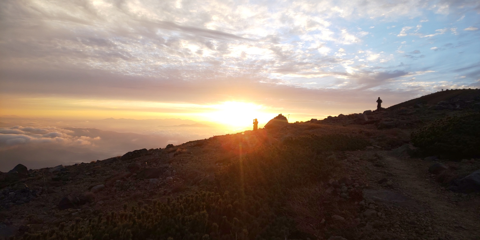
I departed Kyoto at 0542 in the morning on Friday, with good weather seeming to be present, and soon arrived at Kiso-Fukushima (木曽福島) in Nagano prefecture at 0930 in plenty of time for a bus to the “foot” of Mt. Ontake at around 1600m elevation. As I had an hour to kill after arriving at Kiso-Fukushima I did a little bit of sight-seeing and struck up some conversation with the shopkeepers in the area. Upon the suggestion of one of those shopkeepers (who also happened to have a very cute parrot type bird called Haro!) I visited the local Mt. Ontake shrine in the area where you could draw a fortune for only 20 yen! (about 10 pence). As you can see, it felt oddly like a personal attack… Maybe I’ll try listening to those close to me a bit more?After the bus journey to Mt. Ontake, the next step was to ride the cable car up to 2100m elevation or so, taking out a lot of the difficulty of ascending the somewhat behemoth elevation of 3067m that Mt. Ontake has as a whole. A lot of these flowers in the shot were in the process of being planted, which I thought added a certain “niceness” to the area.Following a 10 minute cable car ride, this was the landscape that greeted me when looking back on where I had come from. Although unclear at this elevation, in the distance to the right hand side are the Southern Alps, hosting a number of famous mountains, including Japan’s second tallest mountain, Mt. Kita (北岳), which stands at 3193m tall. After a short respite at this point, I continued the rest of my journey on foot, with a starting time from this point at approximately midday. This marked the beginning of the footpath for prospective hikers, with the initial part of the trail consisting of somewhat worse-for-wear wooden steps where boulders would often be strewn across the path. With hiking boots this would not prove to be an issue, but I would not recommend this in sandals or anything of the sort! Additionally I thought that the colouration on some of the flora was fairly pleasant, clearly being indicative of the Autumn to come.Following a fairly strenuous 1 hour continuous uphill battle, this is a viewing point just past the 8th base camp on Mt. Ontake. Some day-trip folk would ascend the cable-car, go as far as the 8th then return, but for me my goal lied a good 600 metres further up the mountain! For a bit of respite I joined these Buddhist statues for a drink of water and gazed across the Kiso valley for about 5 minutes or so, before continuing on my way. Another sign of the heavy Buddhist influence on Mt. Ontake, this statue appeared to be made out of either obsidian, ash, or some volcanic rock of sorts, which was incredibly pretty in person (my camera didn’t do it justice!) There were a number of statues like this along the path up, and I would often come across the real deal (actual monks, not Buddha himself!) ascending the mountain, fulfilling the historic tradition of ascending the mountain for religious purposes.This was taken a good 20 minutes after the previous shot, and I would guestimate the elevation at around 2500-2600 metres. The cloud cover would come and go incredibly quickly, despite there being a lack of strong winds, which meant that, fortunately, paired with the strain of the ascent the cold would not be an issue until reaching the summit. This was taken facing approximately due South, and the ridge captured in this shot trails up the rest of the mountain and contributes towards the main peak of Mt. Ontake, Kengamine (剣ヶ峰)Elevation approximately 2800m, this was the point where I finally broke through the cloud cover, and could begin to make out distant peaks belonging to either the Central or Southern alps looming in the distance. In the middle of the shot to the left is the 8th base camp, which from this point is approximately 1.2/3km away.Approximately 2900m elevation, this point marked the end of the incredibly rocky and quite frankly, volcanic, mountain path that I had been trudging up for a good 50 minutes since the 8th base camp. Along the way I passed a couple of mountain lodges, as well as the 9th base camp which was unremarkable in comparison to the 8th. From here the path followed a gradual incline of around 150m to our final stop for today, the peak itself. This shot was also taken facing the same way as the previous picture – looking towards the Kiso valley (obscured by clouds) – in other words, East.The blazing sun marked my heading here, which can be seen clearly jutting out in the centre of the shot, with the volcanic crater itself slightly to the right of that. Due to certain restrictions in place post-eruption in 2014, this is the only path to Kengamine, whilst previously one could have done a loop course round the other ridge on the right-hand side of this shot. After taking a shot water break here, I continued on with a fresh wind in my sails, as I could finally see my goal!The final set of stairs prior to the summit. Hand rails were odd to see, and I suspect they were newly implemented post-2014. Spending time at the summit itself is also limited, so I made sure to ready my camera to be able to evacuate the area as soon as possible!A shot taken from the summit of Kengamine, 3067m elevation, facing South-South-West. The beginnings of a sea of clouds similar to what I saw in Tateyama back in June were beginning to appear, but these would soon disperse later on in the evening. The ridge jutting out in the centre of the shot was inaccessible due to the eruption too, with diggers operating nearby suggesting that would not be changing any time soon in the near future. The time here as of taking this shot was approximately 1400/1415pm. A picture of the volcanic crater itself in all its glory (not exactly Hollywood style lava bubbling everywhere!) – it was very serene at the summit, and as I was the only person there I managed to enjoy relative peace and quiet for 5-10 minutes or so. Myself, pictured at the summit of Mt. Ontake’s tallest peak, Kengamine, 3067m elevation. I opted to wear contacts and sunglasses in lieu of my prescription glasses for once, and I do not regret that decision at all, as it was incredibly bright at the summit! Also, although not a legal requirement per se, it is typically recommended to wear a helmet when ascending volcanic mountains in Japan, so the red object I am holding in this shot is exactly that – my helmet! Following these pictures I quickly evacuated the summit area and retreated back downhill towards my lodging for the evening – Ninoike Hut (二の池新館ヒュッテ) – which was a steady 30 minute walk away. As a fun bit of trivia, Ninoike (literally, two lakes – although there was next to no water in them at the time due to no rain as of late!) is the tallest volcanic lake in all of Japan, situated at an elevation of approximately 2900m!This was taken in the evening following my check-in to the mountain lodge. I finally figured out the night setting on my camera, so was quite pleased with how this and a number of others came out! There was a full moon out on this evening, so all of the stars were not visible, but still pretty nonetheless, I think!A friend I made in the mountain lodge snapped this picture of me gazing at the moon, with the Kiso valley still shimmering away to the left.Following an early bed time (by my standards) at 2030, I awoke the next day at 0430, and after reading for a little while went to look at the sunrise, which promptly made its appearance at 0542 sharp. Clouds were rapidly beginning to make their presence known in the lower altitudes, so I feel lucky to have been able to have snapped this shot.Another shot of the sunrise, taken on my phone instead, with a couple of individuals from the mountain lodge also taking similar pictures. Fairly aesthetic!After breakfast at 0600, I set off with a couple of new made friends at the mountain lodge for a short adventure around the summit of Mt. Ontake – climbing the second tallest peak on Mt. Ontake and visiting a couple of the other lakes was on the agenda! This was a shot taken facing East-North once again, and Sannoike (三の池) can be seen (in not so good lighting) to the bottom left. This was taken at around 0800, with the morning temperature being around 8 degrees Celsius or so.Taken from the top of the second highest peak on Mt. Ontake, Marishiten. Looming in the distance is Mt. Norikura (乗鞍岳), with an elevation of 3026m. Mt. Norikura is accessible via car (making it one of the highest mountains in Japan to allow such access), and is on the utmost Southern tip of the Northern Alps. The shadow looming behind Mt. Norikura then, should I guess, is likely Mt. Okuhotaka (奥穂高岳, 3190m) – the “ruling” mountain of the Northern Alps. Although not exactly perfect weather, this sight was very pleasant to look at.Mt. Ontake’s “Marishiten” (摩利支天) summit marker. Although this picture doesn’t do it justice, there was next to no space to navigate around here, although it did offer incredibly rewarding 360 degree angles to admire the surrounding environment!Looking down at Gonoike (五の池) – literally “5th lake” – and the mountain lodge that is situated nearby. The area jutting out behind the hut also makes up one of the other peaks of Mt. Ontake, but we did not have time to do the loop course this time, so we settled for resting at the mountain hut temporarily. Mt. Norikura and the Northern Alps can still be seen lurking behind in the distance too.Hot chocolate and biscuits at the mountain lodge seen in the previous picture, this time looking back up from where I took the other picture! The contrast in sky conditions when facing South was fairly interesting at the time I thought, as the clouds appeared to be following me wherever I went!Some rays of early morning sunshine illuminating the Kiso valley to the East, with what, I believe, makes up the beginnings of the Southern Alps also pictured in the distance. Another Buddhist statue with Mt. Ontake’s Kengamine peak pictured in the background. This statue had pretty trendy glasses on!Following the previous picture our descent begun at around 0920, and took a brief 1 hour 40 minutes, despite the huge amount of people ascending the mountain. According to the mountain lodge staff, an estimated 1,200 people were to be ascending Mt. Ontake on that day, so perhaps I was lucky that I ascended the day before! Pictured here is another hot chocolate, this time taken at the top of the Ropeway, which conveniently has a restaurant type building built into it. Following our break after descending, my new made friend at the mountain lodge kindly offered to give me a lift in her car back to a JR station, so after I had bid my farewells I hopped on a train and Shinkansen back to Kyoto, arriving at approximately 1800.
And there we have it! Mt. Ontake was, as I find with many mountains, incredibly enjoyable. The weather was perfect, and despite there being a lot more people than what I am usually used to, I really enjoyed the opportunity to wind down with people that have similar hobbies in a mountain lodge environment. The ascent itself was fairly tough, but with an approximate 900m elevation change, it is not as extreme as the Mt. Kisokoma/Mt. Utsugi circuit I completed back in May, and this is particularly helped by the fact the ropeway station and 8th base camp both stock supplies should one be hiking in season (July-November, typically).
In closing, I really enjoyed Mt. Ontake. Despite there being a comparatively “small” elevation change by my standards, I felt really accomplished when reaching the summit – and seeing my first volcanic crater was quite breathtaking. My next mountain(s) are undecided, but I’ll be sure to update here whenever I go somewhere new!
Office worker based in Tokyo, Japan. Native English speaker, Native fluency in Japanese (Can translate to a degree). Very large interest in mountains and other nature-abundant areas, and also my blog's namesake.
View more posts