Hello again everybody, it’s me again. This is the second and final day of my Northern Alps expedition this time, and although today had an incredibly unfortunate ending, it was just as unforgettable as yesterday. Mt. Tsurugi lies before me today and the extensive amount of climbing proved to be both a challenging and fantastic experience, and I really enjoyed myself. Anyways, as with my other Alps series I’ll let the pictures and captions do the talking!
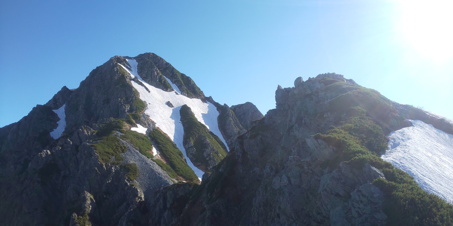
Looking back up at the massive expanse of snow that I made my way down yesterday evening. The idea of navigating my way back up this monster with a full pack seemed very daunting, but unknown to me at this point that would be the least of my worries!The area that I’d cleared out for myself last night to make camp, with Ippuku-Tsurugi (一服剣), Mae-Tsurugi (前剱岳) and big old Mt. Tsurugi herself looming over me in the distance. As a slight spoiler for later just in case I forget to bring it up, although I had pegged down my tent, it actually blew off down the valley due to a thunderstorm later on in the day, taking with it the majority of my hiking goods, as I’d chosen to tackle Mt. Tsurugi packless (the climbs are rather dangerous fully burdened). Oh well, I guess! Anyways I set off from camp at 5am, after arising at 4am, having some breakfast and planning out the intricacies of my route.A clearer shot of Tsurugi and the ridge that leads up to her. As you’ll all get to see later, there is a monster of a glacier that runs down Mt. Tsurugi’s Eastern side – one of only 3 in Japan, supposedly!The sunrise peaking out from behind the Eastern range of the Northern Alps. With it was a wallop of added heat that provided an additional challenge and extra snowburn, but that’s part and parcel of the charm! This was taken at approximately 0515AM.The “path” I was following along to Tsurugi’s ridge. Someone had been kind enough to walk along this way before me (however many days/weeks before!) So it was a simple task of tracking their steps along. Doing so provided ample amounts of footing, and made the slightly inclining snow a bit less intimidating to traverse across.The greeting sign for hikers at the foot of Mt. Tsurugi’s “trail”. I opted to attempt the shortest route up, but…This 30 degree slanted expanse of snow said otherwise! I attempted to stubbornly make my way up it, but I kept sliding down, so eventually resigned myself to turning back and finding an alternate route.My “alternate route” consisted of looping back round to the trail sign, then taking a southern route up to a more thawed out path to Tsurugi’s ridge. In total I only added on around 45 minutes or so, and added in a bit more scenery enroute. Anyways, this shot is following the ascent up to the ridge, facing Mt. Tsurugi. I honestly could not have asked for better morning weather I feel!Some early summer flora on the ridge. Maybe some of you with green thumbs out there may be able to identify what strand of plant this is…?Looking back at the dynamic, sweeping landscape the view from the ridge provided. Although not pictured (and unfortunately you’ll have to take my word for this) the roaring of a waterfall could be heard from this point, which I suspected to be Shomyou Falls (称名滝) – a relatively famous waterfall that can be seen on clear days like these on the Alpine trail up to Murodo terminal. Obviously, with my attracting rain like a magnet, they were not visible yesterday due to cloud cover!!! The falls would be just beyond the bottom right of this shot.A shot demonstrating the sheer steepness of Tsurugi, with a lovely shot overlooking Toyama city in the distance. This was certainly a pleasant contrast from yesterday, considering nothing was in sight on account of the clouds!The snow drifts on the way up Mt. Tsurugi, particularly around Mae-Tsurugi’s area showed the severeness of attempting some of the more difficult routes. Although I was certainly equipped for standard snow mountain climbing, this was a bit beyond my level!Looking back on the valley from which I’d travelled from – it honestly seems like a massive distance away from where I am at the point of shooting (Mae-Tsurugi) – but it was likely only a few kilometres or so! Mt. Bessan is the left most peak in the shot, with Mt. Tate’s peaks jutting out just behind!Although it had taken a bit longer than expected, this was the last peak to climb – Mt. Tsurugi herself. Although from this picture the snow may appear to be quite the obstacle, the route itself was predominantly on the thawed out areas – so it proved to be of little issue. My fairly lightweight crampons assisted in small parts too!The chain works continuing, and providing an ample challenge to shimmy across! Even if one were to fall from here you’d be cushioned by the snow, but I wouldn’t really want to risk taking the chance!A sweeping shot of what, I am fairly sure, is a glacial ridge. Also, bonus points if you can spot the two people hiking up the glacier itself! (I said hello to them a bit later on too!) I would guess the angle of steepness as being around 50 degrees or so, so the necessary footwear was definitely necessary, even to make a brief crossing over!After ascending “カニのたてばい” – The crab’s ascent? There’s approximately a 50 or so metre drop here, so one needs to be careful when scaling the sheer cliff face. You have chains and a few pegs to assist, but I would highly recommend against trying this without some confidence in your stamina! Also I’d recommend leaving your baggage at the bottom! (The two who had ascended the glacier’s baggage can be seen in the right of the picture – they were having a break, I believe!)The final area just prior to the peak itself. Incredibly rocky – but a welcome relief from the rather absurd amount of snow up until this point!This was taken at the peak. I believe I took it facing due East – so those mountains in the distance would be the Eastern ridge of the Northern Alps – an area I’ve yet to explore. Slight hints of yet another sea of clouds just behind the ridge too – it’s a shame that my camera can only capture a limited amount of how pretty this all really was!!Myself looking rather snowburnt from two days of hiking in clear weather! The shrine itself had a plaque that you can pick up and has the height indicated on it, but I decided to leave it be, attempting (badly) to squat down for a picture. A big thank you to the kind woman who offered to take my picture at the top too! In the background to the right you can see the beginnings of the Tate valley, and these views are contrasted by those to the left (East), with Murodo Terminal’s “plateau”.One final picture of the sweeping landscape of the area that I’d traversed up/from on the way to Mt. Tsurugi’s peak. To the immediate right are Mae-Tsurugi and Ippuku-Tsurugi, whilst on the left and in the distance you can make out Mt. Tate and her distinctive three peaks. A rather long and carefully planned out descent was to begin from here!“The Crab’s descent?” = カニのよこばい – I was much more cautious about the descent rather than the ascent with the crab areas, as I’d read some rather horrific stories of people losing footing here and tumbling down 50 plus metres. As such, this leg took around 20 minutes or so to traverse, compared to the 10 minutes or so the Crab’s Ascent took. Although incredibly unclear in this picture, I came across a mountain grouse – otherwise known as “thunderbirds” in Japanese (雷鳥). There was due to be a thunderstorm later on in the day, so maybe he/she was lingering around in preparation for that? (They’re lurking in the shadows in the centre of the picture, just behind the rock)A rather unfortunate omen of what was to come.
And that’s where my pictures end. The fog had begun to roll in, and just as I’d gotten past Mae-Tsurugi I slipped on a snow drift and slid down for 10-15 metres or so before tumbling down a sheer cliff face. Fortunately for me, the drop from the cliff was only 10-15 metres, but just as I went over the edge I blacked out. I think I will write up the incident’s account itself in more detail with a separate post/writings – so please forgive me for the rather brief cut-off there.
As for Mt. Tsurugi – well – ending aside I really enjoyed it. It was a nice mix of difficult and relatively simple (in terms of ascent gained – if compared to Mt. Kisokoma for instance) – but one should definitely be adequately prepared in the snow months (yes, late June still counts as a snow month). Difficulty I would place as a 5/5, but the stamina requirement itself, should one pace themselves, would be a 3-4/5 – with places for breaks being adequately placed (The crab’s ascent/descent DEFINITELY require a small break before challenging – purely for your own safety’s sake!!!)
Anyways. As mentioned, I will likely get to work writing up my incident at full length at some point in the near future. I am currently healing (fairly rapidly), so will be taking a short hiatus from mountain climbing for the short-term – but I may tackle a few smaller treks once my body allows for it. Stay safe everybody, and until next time.
Office worker based in Tokyo, Japan. Native English speaker, Native fluency in Japanese (Can translate to a degree). Very large interest in mountains and other nature-abundant areas, and also my blog's namesake.
View more posts