Hello there everybody, I bring to you the beginning part of the Northern Alps series – as I didn’t want to attempt all 13 100 famous mountains within that range in one trip! In this journey from 20/06/20-21/06/20 I set out to tackle one of the three Holy Mountains in Japan, Mt. Tate (立山、3015m), and Mt. Tsurugi (剱岳、2999m) – infamous for being difficult on account of its many rock climbing areas. I will be honest with you all at this point: This expedition did not have an ideal ending, and resulted in me being hospitalised for a week – but I hope that I can cover the details of this in more detail in a subsequent post – please bear with me on that count.
As for the route that I took to get to the Northern Alps, this was a bit less intense than some of the other hikes I’ve participated in so far. First I took the JR Thunderbird from Kyoto -> Kanazawa (金沢)- which took around 2 hours. Following that I took the Shinkansen to Toyama city (富山). Then a change to the Toyama-dentetsu (富山電鉄駅) service bound for Tateyama station. And finally, I took the rope-way/bus service (Alpine route) bound for Murodo terminal (室堂) – with a starting hiking altitude of approximately 2450 metres.
Anyways, as with my other “Alps” series – I will let the pictures do the talking here too, I think – and keep my thoughts to the captions of the pictures, with a little conclusion at the end. Thanks as always for tuning in!
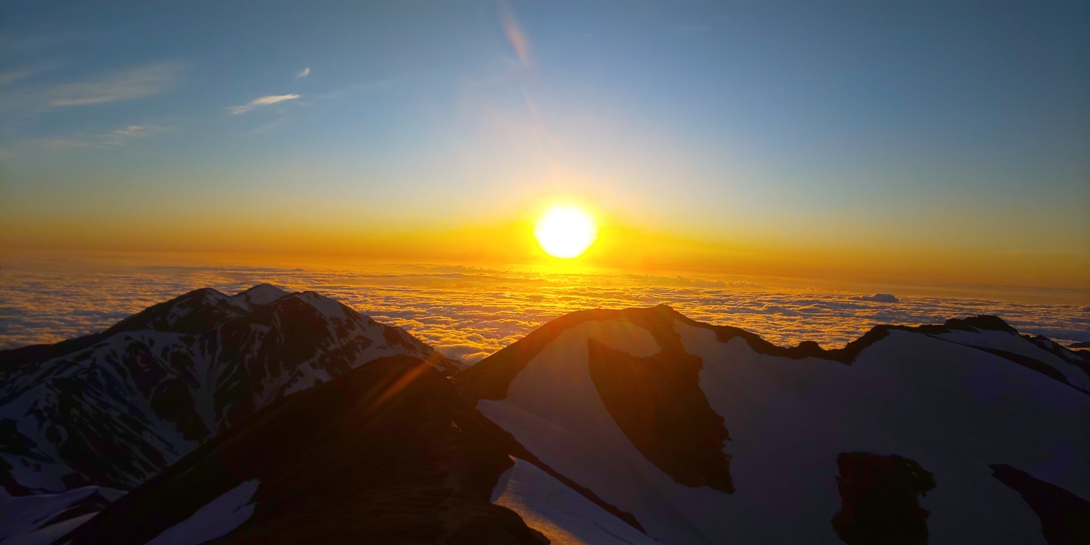
A fairly simple breakfast on the Thunderbird bound for Kanazawa. I was acutely aware that I was likely lacking calories with just a salad – so I purchased a “Curry bread” too – one of my favourite go-to’s. I also met two other hiking friends on this journey – and they were heading towards Mt. Arashima (荒島岳) – changing trains at Fukui (福井) on the way to Kanazawa. I exchanged LINE’s with them, and we also took a picture together! After about two hours I arrived at Kanazawa, made the change over to the Shinkansen, arrived in Toyama, then took the 50 minute express Dentetsu service over to Tateyama station. The outside of Tateyama station – as one has to go to the ticket office outside to purchase the ticket all the way up to Murodo terminal that utilises the rope-way and bus through the Alpine route. I imagine on a clear day one would be able to see the Northern Alps looming over you, but there was no such luck today! Temperature was a rather muggy 20 degrees, but as I would come to find out later, this would rapidly drop once one gained altitude. After a bit of milling about outside, I rode the rope-way up 500m, then got on the bus for the hour ride to Murodo terminal.A shot I took from the bus window on the way up. Judging from the dispersing clouds, I would guestimate this as around 1500-1700 metres – as above that point the skies were crystal clear. Beginnings of snow drifts starting to appear would also suggest around the same height – as the central alps had snow around the same level.Following the rather long journey I had a little walk around the surrounding area of Murodo terminal, and found a bench to have some lunch on – with this stellar view to boot. I imagine this pond/lake is fully thawed out by late August, but the late June views are also nothing to turn your nose up at! The mountain in the background on the right hand side is Mt. Tate. If you squint your eyes you may be able to make out the shrine on the right-hand-side peak.The beginning of the snow-covered path to Mt. Tate. Although this may appear difficult to walk on, it was a cake-walk compared to the snow found in the central alps, but still provided an ample challenge! The snow “leg” from here was about an hour – where a thoroughly thawed out rock path would then await hikers. Half-way up the rock path following an hour of walking through the snow from the previous picture – looking back at where I’d come from. As you can tell, the clouds in the background are practically forming an ocean – which in Japanese is referred to as “unkai”/雲海. The first time I’d seen such a sight, and breathtaking to say the least! (The high altitude itself was also somewhat breath-taking, as it was a bit tougher to breath than usual!!)Following a brief 30 minute or so walk up the rock path, there was a respite hut placed on a fork in the path, where should one wish to venture further south into the Northern Alps, that option was available. Fortunately, I’m not quite insane, and as such vouched to just the northern fork and continue up to the first of Mt. Tate’s three peaks – Ooyama (大山). Before doing that, however, I couldn’t resist grabbing a shot of this mountain ridge to the south – where a line of the Northern Alps’ peaks can be seen. The peak in the central right of the shot could very well be Mt. Yari (槍ヶ岳、3180m) – an incredibly challenging peak of the Northern Alps – and one that will likely be towards the end of my Hyakumeizan journey!!A respite point about thirty minutes up the northern fork from the previous picture – this shot is taken facing south. The wind picked up rather drastically at this point, requiring one to be rather careful when navigating the rocks heading up. Although I’ve mentioned it previously, I can not state enough how pretty/breath-taking the clouds were when looked at – I’ve seen such images in films/popular media before but I honestly felt blessed to be experiencing it first-hand. A similar shot to the one from the fork-respite point two pictures earlier, only about 100m higher. Oddly enough in this shot there appears to be cloud cover above us, but in reality that was a rather negligible amount – perhaps my camera picking up unnecessary details…?About another 50m up from the previous shot, this time facing East! From Mt. Tate there is about a 600m drop should one head north, where you would find Kurobe Dam (黒部ダム) – standing as Japan’s tallest dam – having a drop of 186m. Although I am unsure, I heard talk from the guides on the way up to Murodo that should one face south-east you could be able to make out Mt. Fuji’s peak – but I can confirm that unless you have eagle vision that would be highly impossible. The shrine entrance leading into Ooyama, the first peak of Mt. Tate. Due to this technically being the off-season – I was blessed with not running into anyone on the way up – probably due to the comparatively late time by Japanese standards that I was hiking. Nevertheless, a very pleasantly quiet time!A picture taken facing due-North – with Mt. Tsurugi protruding upwards in the centre of the picture. The walk along the widge following ascending Mt. Tate was incredibly leisurely (If compared to the monster hike I had from Mt. Kisokoma -> Mt. Utsugi in the central alps!) – and I also got to enjoy a nice breeze along the way. Although the drop may seem incredibly precipitous from a distance, there was a fairly large amount of space to walk along. The final ascent up to Mt. Onanji (大汝山) – standing at 3,015 metres – and the first peak I’ve ascended to stand above three kilometres. Taking care around the snow at the final ascent!A clearer picture of Kurobe Dam – located to the East and situated in the valley left between Mt. Tate and the eastern mountain range of the Northern Alps. I initially thought that one could see the curvature of the earth on the horizon from this picture, but I think I simply didn’t hold my phone straight for this picture!The summit marker for Mt. Onanji, indicating the highest point of my expedition this time, at 3,015m. This trip up until this point was, to say the least, relatively easy – although the snow had provided, as always, a challenge. All that remained of today was to traverse up the northern ridge, navigating through a few more peaks, then settling down for the day!A stunning shot of the “basin” where Murodo terminal is situated – which can be seen if one squints in the central left of this shot. With the sun bearing down on me throughout this journey I ended up getting viciously sun/snowburnt despite sunscreen, although it helped to also capture the beauty of shots such as this one.Another shot of the ridge heading north, just after the third and final peak of Mt. Tate – which I chose to not ascend due to deterioration/excessive snow blocking the path which would have proved dangerous to ascend willy-nilly. Another shot facing south – I was getting rather wary of the sun – and judging off its position here I’d guess we’re at around 5pm. It was gradually sinking along my walk down the ridge – and likely contributed to the slightly one-sided sun-burn I acquired!Looking back up the ridge from where I’d come from. The three distinctive jutting out peaks in the centre/left are all Mt. Tate!Mt. Masago (Kanji seen in shot) – Often overshadowed by its big neighbours Mt. Bessan (別山) and Mt. Tate, this was a very gradual walk along the ridge and slight elevation to the peak marker! The views to the east from this point were honestly breathtaking, and I slightly regret not taking more shots! There was also a fork at this point to head back to Murodo terminal – but is highlighted as being incredibly dangerous during the “melting season” (Where the snow melts!) – which I just so happened to be right in the middle of, so decided to avoid!Continuing along the ridge, we can see Mt. Bessan in the fore of the shot, with Mt. Tsurugi peaking out from behind. This entire landscape honestly felt rather dreamlike, and directly taken from one of the Japanese RPG game fantasy settings that I’ve played!The beginning of sunset, with long shadows beginning to be cast over the basin where “civilisation” was! This is taken facing south-west – with the sun suggesting this is around half past 6 in the evening or so!Another sign noting that avalanches are a very real risk during melting season. I aptly decided to avoid this route for such reasons! From here there was a mere 15 minutes until Mt. Bessan’s southern peak!The “peak” of Mt. Bessan on the south. Mt. Bessan is in fact, split into two peaks: South and North, although as this picture slightly captures – the venturing over to the northern peak would be more than a bit dangerous – so I opted out of that option! I particularly like in this shot that the snow and clouds seem to blend in with one another – almost providing a desert-like landscape.Mt. Tsurugi in all of her glory. I was required to take a rather steep 300-400 metre descent down to the campsite from Mt. Bessan’s southern peak prior to ascending her tomorrow, but it would be all the more worth it, I was sure!Walking along the East-West ridge that runs from Mt. Bessan, in an effort to find the path down to Tsurugisawa Campsite (剱沢キャンプ場). I would find that the path itself was in fact COMPLETELY snow covered, resulting in a rather careful 30 minute trek down a snow drift for 300 metres or so! This shot itself doesn’t need much explaining, with the sun providing an astoundingly beautiful contrast to the sunlight colours in both the sky and the “sea of clouds”.Another ethereal shot of the basin from whence I originally came! One would sincerely doubt that this is in fact June, rather than say, early spring/late winter!Looking back at Mt. Tate under the sunlight. Honestly these sorts of views made the trip all the more worth it, even with my rather unfortunate outcome.My concluding shot from today’s hike up Mt. Tate. The sky lit up in this colour for the last 10 minutes or so of the sunset – and the streaky clouds in the sky really add to the overall picture, I feel.
Anyways – that was the end of my first day of hiking in the Northern Alps! Following the picture above I took a steady 30 minute trek down an expanse of snow to Tsurugisawa Campsite, and made camp on rather unsteady ground – and settled down with some nice beef stew for the evening. I documented my day in my mountain journal, and got to bed by about 21:30 for an early start of 04:00 the next day.
Stay tuned for when I update you all as to how my second (rather unfortunate!) day unfolded!
Office worker based in Tokyo, Japan. Native English speaker, Native fluency in Japanese (Can translate to a degree). Very large interest in mountains and other nature-abundant areas, and also my blog's namesake.
View more posts