Hello everybody, long (ish) time no speak! Recently I took an expedition out to the Japanese Alps in Nagano Prefecture, or more specifically, the “central” alps – which is comprised of the Kiso (木曽) mountain range. My hike this time also introduced camping to me for the first time ever – so I’ll split this blog into two parts: the first of which I’ll cover the ascent and the first mountain on the agenda (Mt. Kisokoma – 2,956m elevation), then the second part I’ll cover the trek over the mountain ridge to Mt. Utsugi (空木岳、2864m elevation). Also, due to the nature of how many pictures I’ve taken, and for not wanting to drown you all in text, I’ll make these next couple of posts picture heavy, and stick to explaining in the captions I think. The sights were to die for, and I certainly wasn’t expecting to have my first taste of snow in 2020 in late May!
So, first of all, in terms of access there’s a few points you can access the central Japanese alps, but I chose to start from the small town of Agematsu (上松). From where I’m based in Kyoto it took a total of ~3 hours via the Shinkansen bound for Nagoya (名古屋), a change over to the JR to Nagiso (南木曾), then riding the local one-manned train through the valley up to Agematsu. Should it be of interest, I’ll put a map below!
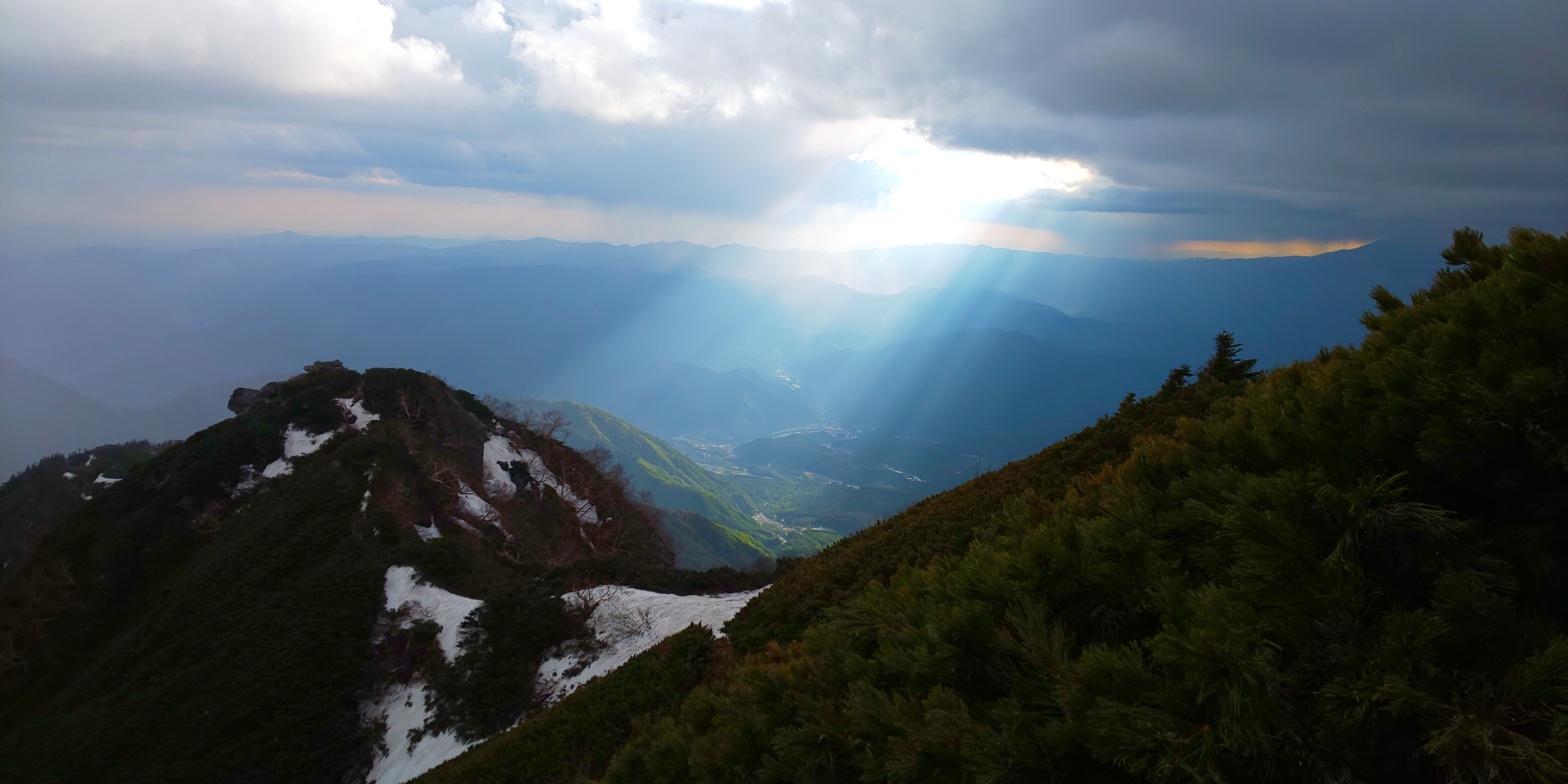
An approximation of the route taken from Kyoto. The yellow highlighted section to the right of Agematsu is the mountain range in its entirety, and the two red dots are the two Hyakumeizan on the agenda for this journey. The northernmost being Mt. Kisokoma, and the southern one being Mt. Utsugi. (The southern red dot’s a bit off by the way)An early, 0530 start calls for a bit of extra spending on the Bullet train’s breakfast deals! The bullet train leg itself only takes 30 minutes from Kyoto-Nagoya, whilst the rest of the journey is dominated by the other JR trains to Nagiso/Agematsu.Arrived in Agematsu just past 0830am, and the weather was looking very promising! This picture is looking back, South, down the Kiso Valley, with the Alps themselves located on the left. Temperature was fairly moderate at this point, sitting at around 20 degrees Celsius – A fairly mild early summer morning.About an hour after the previous picture was taken. I noticed that there was increasingly less people as I ventured East into the mountain range, and despite there being roads, there was no traffic at all. Consequently, I decided now would be a better time than none to equip my handy クマよけ鈴・Bear-repelling bell! Bears supposedly associate the sound with humans, and depending on their nature will more often than not attempt to avoid the noise as they intrinsically don’t appear to seek out confrontation with humans if it can be avoided. Sapporo’s ヒグマ・Higumas on the other hand…!Before I knew it it had seemed I’d walked just over 4km into the mountains! Only a little bit left until the start of the rather steep ascent up to Mt. Kisokoma from here. Oh, and on an aside, I happened across a rather strange creature at this point (I didn’t take a picture for fear of spooking it). In Japanese they’re called カモシカs apparently, and from what I could find they’re similar to wild goats – something I was unaware of Japan having. It was grey, around the size of a dear and had two little horns – but looked herbivorous so it wasn’t too frightening! What did take me by surprise, however, was noticing two rather beady looking eyes starting at me through the forest – I feared my bear-bell had betrayed me already…The start of the trail-proper up to Mt. Kisokoma. I left a little message on the chalkboard near the entrance to indicate I was entering, and took a brief respite before beginning too. The trail marker here indicates 7.5 hours required to reach the peak, which, as I would find later, would prove to be a pretty accurate measure! (Starting time: ~1030)The third trail marker after entering the trail (Where’d the first and second go?!) The trail at this point was incredibly heavily wooded – with very little much going in terms of views, and shrubbery was fairly abundant – requiring someone traversing the course to solely rely on the pink trail indicators as can be seen tied to both boards in this picture.Around the fourth trail marker – this, I believe, is Mt. Ontake (御嶽山) peeking between the trees. Mt. Ontake is fairly well known for recently erupting (it’s a volcano) in 2014 and killing over 50 people and wounding many more. This was a major shock for many, as there was very little indication as to when/how it would erupt at the time. https://www.japantimes.co.jp/life/2018/09/28/travel/mount-ontake-four-years-deadly-eruption/#.XtXwX8gzZEY provides an interesting account into the details of the eruption 4 years down the line (2018 at the time of writing).Beginning to see some of the ridge come into sight. About 40 minutes after the previous picture – likely around 1.7k elevation or so.A much more impressive shot of Mt. Ontake. The blessing that I had with good weather appeared to be rapidly disappearing, with the clouds beginning to roll in very quickly!This was at the 5th trail marker, a relief hut for those hiking and finding themselves running out of time. At this stage I was unaware of the mountain huts at the summit being entirely snowed in, but had I known I would have liked to have stayed here!Another shot of the mountain ridge of the central alps, as seen from the west. Remnants of snow remain on this peak, but as we will see later there is much more than it would first appear!This, I believe, is Mt. Sannosawa (三ノ沢岳) – 2,864m elevation. Although I would have liked to had the time been more generous, I did not get to hike up her. She’s located in the “middle” of the alps, and would have required a 2-3 hour detour to go to her and come back from, but certainly a location that would be nice to revisit again! As we’ll see in part two of this journey, Mt. Sannosawa often dominates shots taken from the mountain ridge facing East.Unfortunately there were no water sources on the way up, so I made do with gathering snow and filtering it for most of the first day. The snow started “appearing” properly at around 1.9k/2km elevation.At around 2.3/4km elevation I’d guestimate. A nice wide shot of the mountain ridge of the central alps as seen from the West. Mt. Sannosawa is out of frame in this picture, and she’d be just to the right. Slap bang in the middle of this picture, I believe, is Mt. Hōken (宝剣岳, 2,931m), and will be a challenge to overcome for day two. Although not covered in this picture, thunder was beginning to roll over the mountain ridge at this point, acting as a rather strong incentive to hurry up!Looking out East/South-East. The weather unfortunately seemed to be fairly nice down in the valley, but it seemed like a storm of sorts was certainly approaching!This is the same direction being looked at, but 30 minutes later, and about 200m higher. Certainly a storm! Interestingly from a distance it appeared to be rain, but I was experiencing light/medium snowfall instead. I suppose that’s natural with the temperature difference!This was the penultimate “peak” to climb before descending briefly then climbing once more up to Mt. Kisokoma. Although not captured here, there was a rather large amount of snowdrifts obstructing the way on this course – causing some irritating delays.This was probably around 1700/1730, and 2.7k elevation, capturing Mt. Ontake in all of its glory. Slightly different angle from the previous shot, instead capturing the Kiso valley being bathed in rather selective sunlight. Mt. Ontake is out-of-shot to the right, and the mountain peak to the left is the course from which I came.Bidding farewell to my trusty stick that had accompanied me up from the third trail point. It was getting difficult to navigate the rock faces with both hands occupied, so I opted to leave him behind here. Mt Sannosawa can be seen in the clouds behind, with this shot being taken facing south-south-east.The final descent before the ascent up to Mt. Kisokoma’s peak. As you can tell, the “relief hut” (blue) in the middle of the picture is completely snowed in, not allowing for any visitors at this time! This snow was also deceptively hard to navigate. In Japanese it’s called モナカ雪, but it’s frozen pretty tough on the top, but soft on the inside, sometimes causing you to fall around 4/5ft with a footfall. Rather irritating at times!Another beautiful sunset shot over the Kiso mountains. This shot is pretty much from the opposite end of the previous – the snow doesn’t look like much from a distance, but as I experienced first hand it’s quite a lot, even in late May! Winter climbing may be an interesting venture to try undertake for the future.The summit marker for Mt. Kisokoma. Although I’m not sure what the rolling mountains are to the north, I would not be surprised if it was possibly the very southernmost edge of the Northern Japanese Alps?Summit marker + me! Looking fairly energetic despite the somewhat long trek up! I’m VERY glad that I brought my hat – as my ears were still rather freezing!Although fairly unclear from this shot, the final leg of the first day is over to the left, winding around Mt. Nakatake – a somewhat dangerous endeavor in dusk but still required to find a camping spot!The final signs of daylight disappearing behind the mountains to the south. Very eerie.The basic route that I took from Agematsu station all the way to my final camping spot at the foot of Mt. Hōken. Apart from the initial search for the trail head from the station which took around 4km, the trail route itself was fairly simple – with markers at fairly regular intervals.
And there we have it! I camped at the foot of Mt. Hōken – and although conditions were incredibly cold (-2 degrees Celsius), my tent and sleeping bag helped fend off the cold somewhat. I went to bed at around 22:00, for an early start tomorrow starting with Mt. Hōken. Find out more in my next post!
Office worker based in Tokyo, Japan. Native English speaker, Native fluency in Japanese (Can translate to a degree). Very large interest in mountains and other nature-abundant areas, and also my blog's namesake.
View more posts
One thought on “The Japanese Alps! Day 1: Mt. Kisokoma (木曽駒ケ岳)Hyakumeizan #3! 29/05/2020”


One thought on “The Japanese Alps! Day 1: Mt. Kisokoma (木曽駒ケ岳)Hyakumeizan #3! 29/05/2020”