Hello everybody. This is my first post via a blogging format, so apologies if it’s a bit jumbled in places, I’ll try to not ramble on for hours.
So, on the 5th of May Kyoto was blessed with fairly good weather, and I decided to go and visit Mt. Horai, a 1,174 metre elevation mountain, over in the neighbouring Shiga prefecture, in the northern part of Otsu City. Mt. Horai is part of the Hira mountain range (比良山地) which runs between the border of Kyoto and Shiga (and also acts as an impressive hurdle to overcome when heading there via bike!) The mountain range itself is comprised of many peaks, but the most famous of those are Mt. Uchimi (打身山), Mt. Horai, and Mt. Bunagatake (武奈ヶ岳), all standing at 1,103, 1,174 and 1,214 metres respectively. The Hira mountain range is also incredibly famous in Japan for being depicted in The Eight Views of Omi (近江八景), a series of 14th century traditional Japanese paintings inspired by Chinese versions three centuries earlier (Omi is the old name for Shiga, thus, “Eight Views of Biwa/Shiga could translate too). The Eight Views would go on to influence famous Ukiyo-e (浮世絵 – Traditional 17th century Japanese painting style) painter Shirohige to depict the Hira mountains as the following:

Mt. Horai itself is listed as one of the 1997 top 300 mountains in Japan, and the scenery that you’re rewarded with at the peak certainly justifies that, in my opinion. There isn’t much history about Mt. Horai itself that I could find, other than that according to Arai Takashi in his 1997 edition of 300 Famous Japanese Mountains, there once supposedly lived a hermit on the mountain, and was often referred to as a ghost-mountain by surrounding sects of monks practicing on the neighboring mountains within the Hira range as a result of said hermit tale.
Now, moving on from the history, I decided to traverse to the mountain via bicycle. The route I took can be seen below:

The total distance between Kyoto and Mt. Horai, if being generous, is about 35 kilometres one way, or around 21.7 miles. I am by no means unfit, but in retrospect I GREATLY underestimated how taxing the bike leg that runs through the Hiei (比叡) mountain area was. Fortunately, the ascent on the way to Otsu wasn’t too bad as it was around a 6km ascent, versus the 2.5km sudden ascent on the way back to Kyoto (post-Mountain climb!) For reference, Mt. Hiei is around 848 metres at its peak, with the toll road that I passed whilst passing over via bike standing at around 600m elevation.

Having overcome the most grueling part of the bike journey, all that remained was 20 or so kilometres of flat riding from southern Otsu to Northern Otsu. This was incredibly enjoyable as I was flanked by views of Lake Biwa to my right on the way there, and the sun was out too. I suspect due to the pandemic recently not many people were out and about in cars, allowing for a fairly brief 1 hour bike ride up to the base of Mt. Horai.

Upon arriving at Horai station I spotted a sign directing mountain-goers down a road heading West, so I followed this via bike for about 20 minutes going gradually uphill. Gradually is the key word here, as the final stretch of road that was still able to be navigated by a bike suddenly became so steep it put my hometown Sheffield’s Rutland Road to shame (Those who are aware of Rutland Road can sympathise). As a result, I decided to push my bike up the remainder of this road, when I came across a certain warning sign for hikers…
This was certainly a shock, because whilst I was aware of bears existing in Japan, it was the first time I had experienced hiking a mountain where I could come across something “dangerous” other than wild boars/snakes. Either way, I proceeded up the forest road whilst pushing my bike, and made use of my bike bell for a while if my footfall was becoming muffled. Eventually I came across a clearing which marked the end of the road, and I used this area to lock my bike (I seemed to be the only hiker who came via bike today, with one car also parked nearby) The clearing also provided a nice overview of the Horai area near Lake Biwa, as can be seen here:

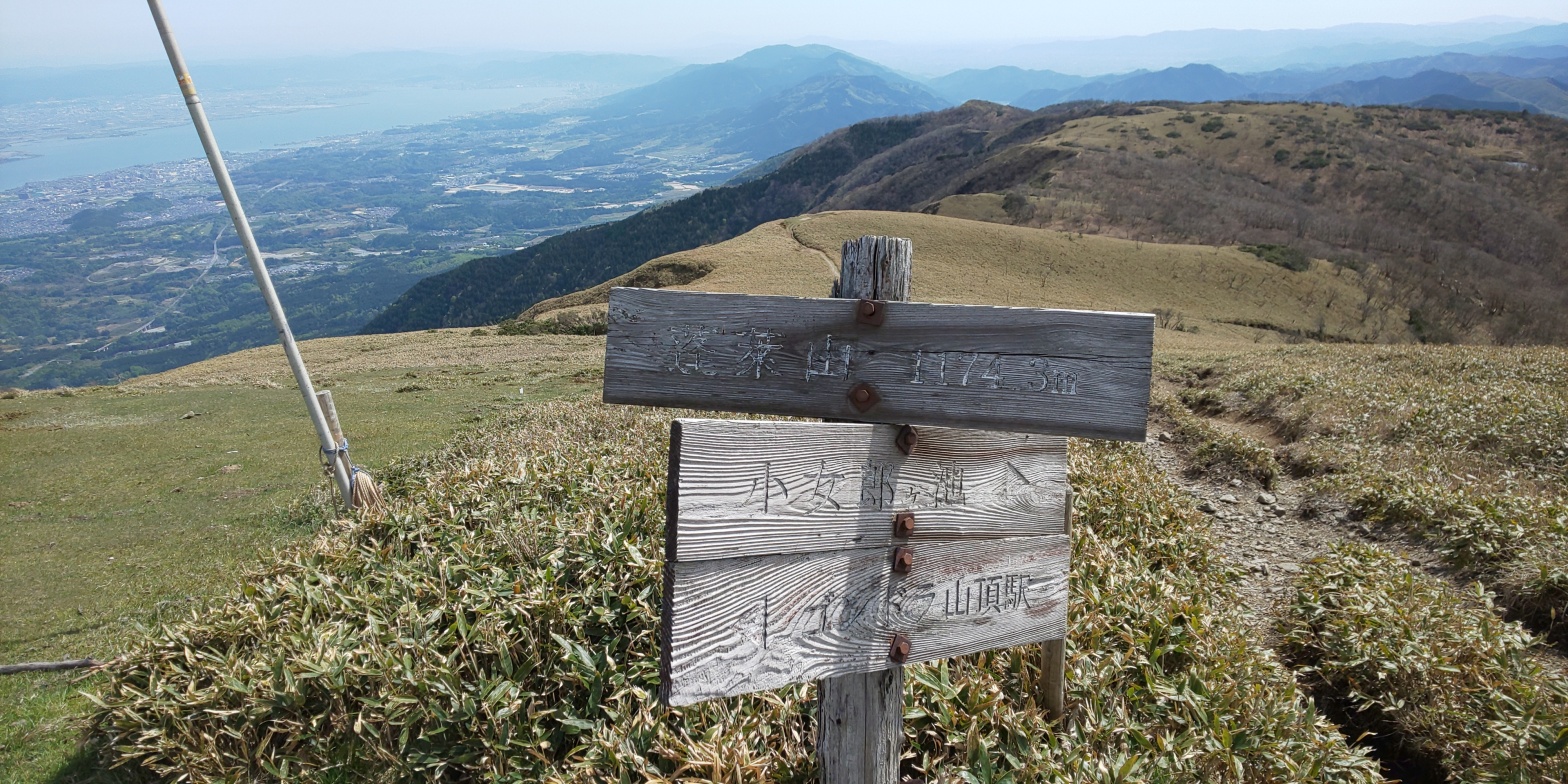
Anyways, from this point on I would be travelling by foot, so I had a snack of a Caloriemate (TM), as well as a green smoothie concoction that was sold at the convenience store and I can’t remember the name of. The path itself was flanked by a fast-flowing river, with rocks acting as indicators for where to go on the trail. Other than the rocks, there were also small bands of plastic to act as guides for hikers, so often I would need to stop to gather my bearings (pun intended?), and look for a marker, so as to not end up lost in the mountain. The trail that I was following was called the Kojorou trail (小女郎峠), and was one of two trails that I identified on the way to the mountain. The other trail happens to lead to a ropeway, but taking ropeways is not in my nature, so I opted for the rocky-trail instead. (Circumstances as they are, the ropeway also appeared to be out of service upon seeing some signage indicating so at the summit)


Following the haunted bicycle, I noted a distinct change in scenery, with things becoming seemingly a lot more barren, with rocks littering the path even more so than before, and very little foliage cover. I took another break there and heard what sounded like humans talking from over to my left. However, upon listening a bit more, I noticed the noises were not human voices, but in fact pigs, or more accurately in this case wild boars. I heard what sounded around 3-4 separate “oinks” or “oinkings”, so I would suspect it was a family. Knowing that approaching wild boards individually, let alone in a family situation where they would have due course to attack you was a bad idea, I decided to cut my break short, just in case the smell of my food carried over to them.


After climbing up the final part of Kojoro trail I was greeted by an incredibly breathtaking view of Lake Biwa and what I had climbed up. The climb up to this point had taken approximately 2 and a half hours at a fairly “normal” pace.


The walk to the lake was a leisurely 5 minutes or so, and the landscape surrounding me was reminiscent of the Peak Districts in South Yorkshire/Derbyshire, so I got a certain sense of nostalgia from walking there. I met an elderly Japanese man at the lake who had seemingly hiked up before me, and as he was eating his lunch I decided to join him and eat my remaining Caloriemate (TM), along with a croissant that I had purchased at the convenience store along with the strange green smoothie concoction. The man himself said he had hiked up Mt. Horai countless times, and that the reason for doing so was that often it was overlooked in favour of other mountains in the area such as Mt. Ibuki (伊吹山), and Mt. Bunagatake, and as a result you could find some peace and quiet there. I would certainly be inclined to agree!

Following the pond, I traced my steps back to the original signage, and took the path leading up to Mt. Horai’s summit. This consisted of traversing over what I assume to be one of the Hira mountain range’s ridges, and involved some ups and downs, but didn’t hold a candle to the severity of the ascent that the Kojorou trail had.


Upon making the final ascent up the shrubbery-lined trail, I was met with a surprisingly built up summit. There was the ropeway building noisily cranking away (albeit with no customers), as well as what appeared to be an out-of-service restaurant, and some traditional mountain markers placed around.


I dithered around taking my pictures for a whilst recuperating at the summit for around 20 minutes, then begun my slow descent back down Kojorou Trail. The descent was (inevitably) much easier than the ascent, and I got down in around an hour and a half. The bike back was (unfortunately) equally as grueling as the way to Mt. Horai, but this was probably a case of you reap what you sow, as I certainly had the option of taking the train there instead! Total time up and down Mt. Horai totalled to around 3 and a half hours-4 hours, with some dithering here and there included in that.
All in all, this journey was incredibly enjoyable, and I would certainly recommend it to anybody looking for a challenging day out. Should stamina be an issue for those interested, the ropeway does operate at a price of 1,000 yen (per way?) so it is certainly an option for those not wanting to brave the Kojorou trail. Either way, ropeway or not, the final view of Lake Biwa certainly justifies the physical exertion needed to get there, so I will definitely be visiting again in the future.
Thanks very much for getting through my rambling. From now I’ll be looking at either ascending Mt. Ibuki in Northern Shiga, or I will possibly think about ascending Mt. Kongou (金剛山) in the Osaka region. For now it’ll have to remain a surprise!
Until next time!
